The design for a wider shared-use pedestrian and cycle bridge at Scarborough Bridge was unanimously endorsed by the council’s Planning Sub-Committee yesterday.
The new bridge will be nearly three times as wide, while the ramps at either end will mean cyclists, wheelchair users and people pushing prams will be able to use the bridge with ease. New steps connecting the ends of the bridge with the riverside paths are also to be built.
The decision means the new bridge is on track to be constructed and in use by March 2019, with its estimated £4.5m cost coming from the council; the West Yorkshire Combined Authority’s CityConnect Programme; and the York, North Yorkshire and East Riding Local Enterprise Partnership.
Works will get underway from next week to construct a new cycle/pedestrian bridge over the York to Scarborough railway line in Haxby.
This will complete a new safe off-road shared cycle and pedestrian route along the A1237 outer ring road, between the Haxby Road roundabout and the B1363 Wigginton Road roundabout, connecting over 15,000 people living in this area of York.
The contractor PBS Construction (North East) Ltdwill fabricate the main bridge structure off-site, and then plans to lift it into place over the weekend of 15/16 November.
The works were originally planned to commence in 2013, but have been rescheduled to accommodate an alternative design to address ground condition problems, and to meet Network Rail’s requirements to enable contractors to have access to and work close to the railway line.
Works to complete the approach cycle paths will start soon after in late November as well as the installation of a new Toucan crossing on Haxby Road. The new path is planned to become fully operational in early 2015.
Unfortunately cracks have appeared in the section of the cycle track west of the railway line which was completed last year. These appear to be due to the dry summer causing ground movement in some isolated areas.
The council is currently assessing its options to address this problem, which may involve relaying some areas of the path surfacing and filling/sealing the cracks.
Neil Ferris, Assistant Director for Transport, Highways and Fleet, said: “This is one of the largest investments in York’s cycling infrastructure since the introduction of the Orbital Cycle Route in 2011 and will invest £925,000 from the government funded i-Travel, and Local Transport Plan (LTP) funding.
“We’d like to thank those living and working nearby for their patience throughout the period of the works and for the unforeseen delays that we’ve experienced. We are looking to find a solution to address the current issues that will be both long lasting and cost effective. In the meantime we have put up signs that say the footpath is closed to deter people using it in the unfinished state, and while the overall route is not available.
“We would urge parents not to allow their children to walk or cycle along this path until the full route is open.”
The measures also include links with Haxby Road near to the roundabout, as well as approach ramps on the existing embankments to the new bridge and an additional crossing point on Wigginton Road to safely connect with Clifton Moor.
In addition to main bridge works, and the construction of the link paths, the council is also planting a new hedge alongside the A1237, next to the new fence line that has been established as part of the scheme. This planting is expected to happen in October/November.
The council intends to also amend the Public Right of Way across an adjacent field just west of the railway, with a view to improving access and reducing potential conflict between pedestrians, cyclists, and agricultural vehicles in this area.
The provision of an off-road route/safe link opens up access (sustainably, via cycling and/or walking) between Haxby, Strensall, Huntington, Earswick, New Earswick and to the retail, leisure and employment destination of Clifton Moor as well as students attending Joseph Rowntree School.
The new cycle route will be the flagship scheme of City of York Council’s four-year i-Travel initiative, made possible by £4.6 million of government funding which the council successfully bid for in 2011.
The Clifton Moor retail, leisure and employment area attracts around 6-million visitors every year and supports 6,000 employees.
In addition to the new cycle route, the council has also addressed the lack of good pedestrian and cycle routes within the Clifton Moor retail / leisure area itself by investing almost £100,000 of government funding in 2013 on new pedestrian and cycle crossing facilities, cycle lanes, and measures to slow traffic speeds, by introducing easier and safer access for pedestrians and cyclists.
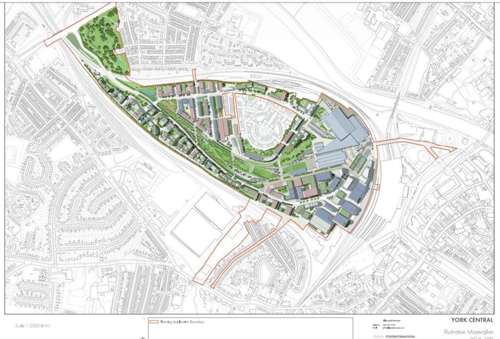
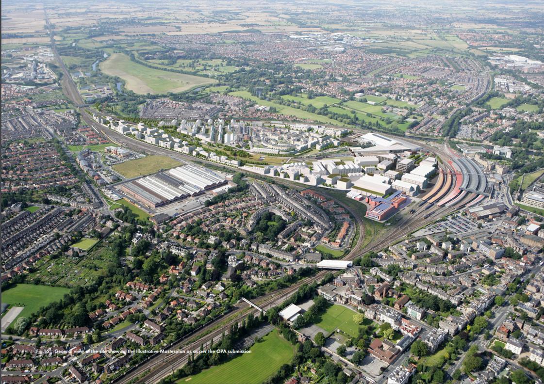
Illustrative York Central Masterplan approved in 2019
The council’s “continued role” in unlocking a new generation of jobs, homes and cultural facilities in the York Central site will be considered by the Executive next Thursday, 22 April.
Funding to complete infrastructure works at the York central site (located behind the railway station) is being made direct to the landowners – led by Homes England – by the government.
It means that the Council’s role will be peripheral despite many millions having already been invested in the project. That may be good news for taxpayers who have seen projects like the Community Stadium and Guildhall refurbishment delayed and go over budget in recent years.
Now contract supervision and liability will rest mainly with Homes England.
Transparency isn’t a strong point for any of the “partners” involved in the York Central project (or the current York Council for that matter). We doubt if engagement will improve under the new governance arrangements.
The Council does remain the planning authority although that role could be undermined as they pursue “Enterprise Zone” status for the project. Planning rules are lax in such areas.
Council report April 2021
The Council is still set to spend nearly £50 million on the project and is dependent on the additional business rate income from Enterprise Zone new businesses to repay its borrowing.
The report being considered next week skates over the risks of this approach,. Those risks appear to have increased since the pandemic with office based developments likely to be less attractive for a while at least.
There are a number of significant planning issues still to be resolved.
These include the (bizarre) suggestion for making the Leeman Road tunnel one way, the absence of an attractive pedestrian/cycle access from the Wilton Rise area and continuing doubts about severing the existing Leeman Road footpath link near the Railway Museum
“Despite the ongoing challenges of the pandemic, the council has worked with York Central partners Network Rail, Homes England and National Railway Museum to maintain momentum and progress on the 42 hectareYork Centralsite.
After partners finalised the £155 million funding, secured planning permission and started work on the infrastructure to unlock the site, which will deliver up to 2,500 homes and space for up to 6,500 jobs.
Executive will be asked to approve changes to the way the project will be delivered and managed.
This includes the main grant holder, Homes England, taking on the delivery of the bridges, footways, cycleways, roads and other infrastructure to open up the site.
The council will also receive £3.86 million from the government grant to cover the costs incurred advancing the infrastructure project”.
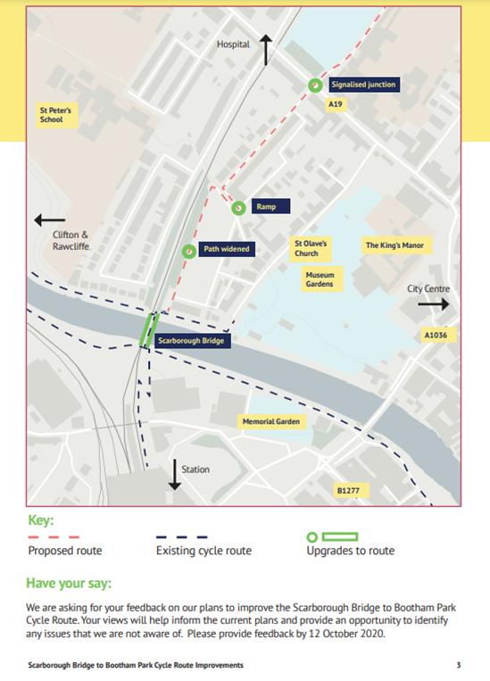
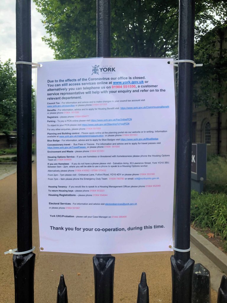
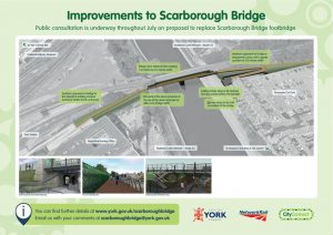
The Council has started an “on line” consultation about the changes that they plan to make to the pedestrian/cycle route which links Scarborough Bridge to St Mary’s, Bootham and beyond.
Unfortunately very few people know about the plans or the consultation.
The background information glosses over the future of the Marygate car park.
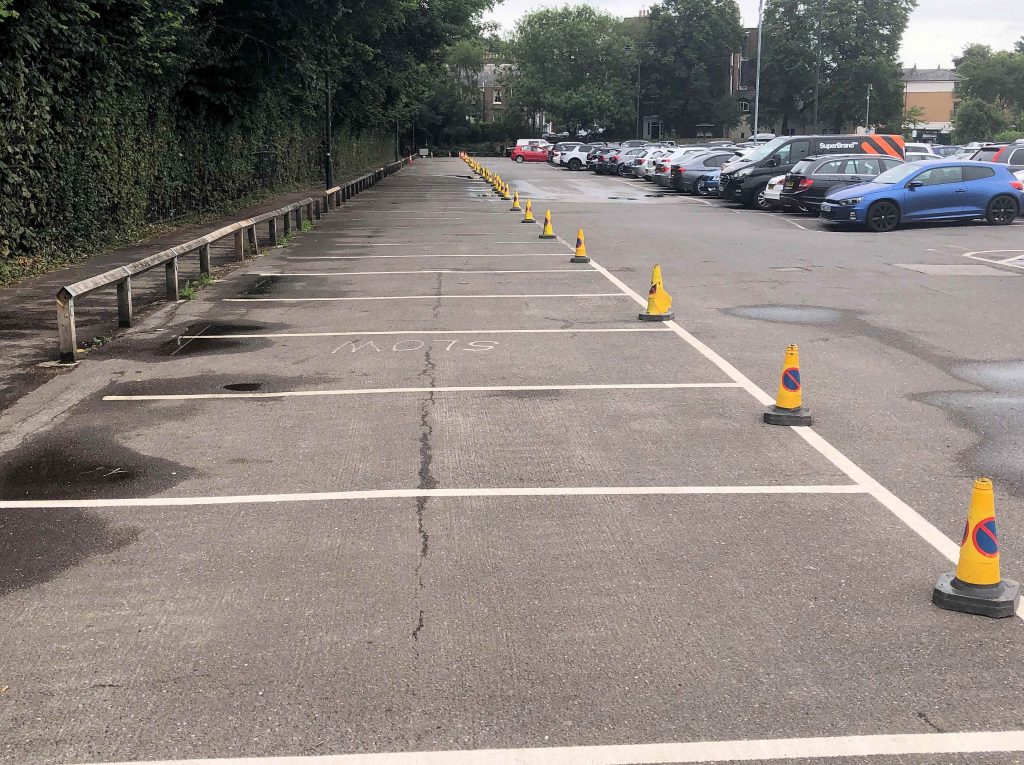
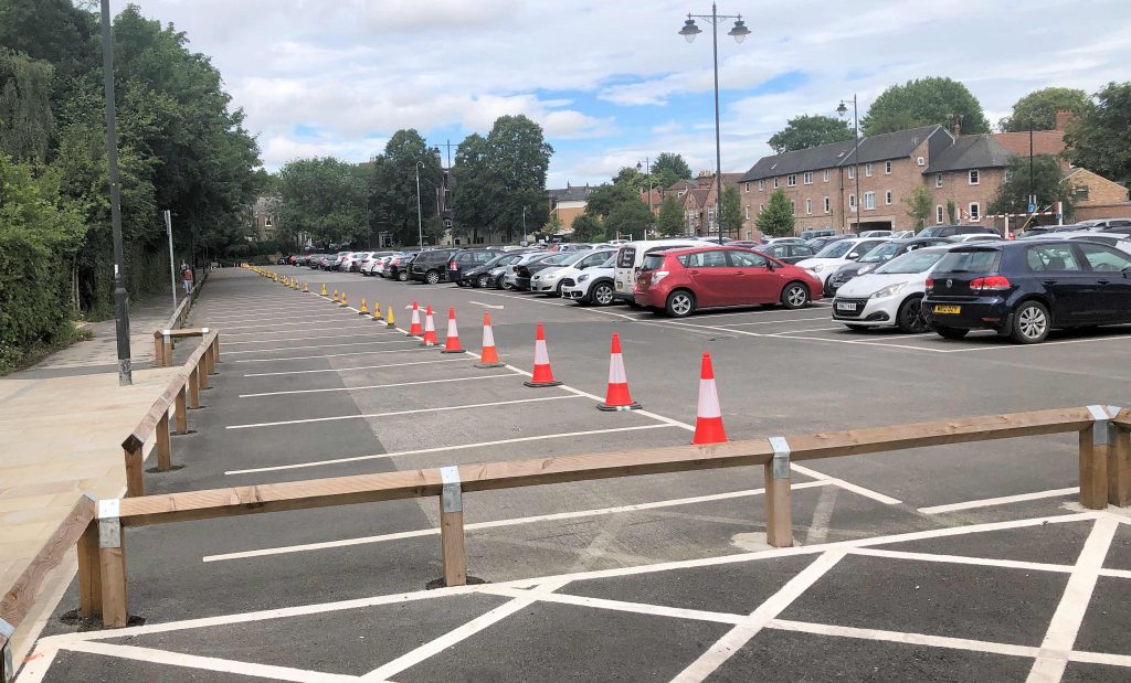
The main area of concern relates to the possible permanent loss of parking spaces in the car park. The car park has been very popular with visitors and shoppers over recent months. It is vital for the City centre economy.
Unfortunately around 40 spaces at the car park have been unusable since the York Council coned them off in June.
Marygate car park full but empty spaces coned off by Council
The consultation document says “Marygate car park will be relined to enable a modest widening of Railway Walk”
It doesn’t say how many spaces will be lost.
There is no opportunity given on the survey to support or oppose individual sections of the proposal. Instead only narrative comments are invited.
It will be impossible to quantify these, so the final decision on the scheme will rest with one York Executive Councillor (Cllr D’Agorne)
Other aspects of the plans are likely to be less controversial.
These include
Construction of a shared-use, low gradient, ramp over the existing short flight of stairs from St. Mary’s to Marygate Lane to enable people travelling by bike or on foot, as well as people with mobility issues to use St. Mary’s as a preferred quiet route.
The improvements here will also include some resurfacing of the carriageway.
Introduce traffic signals at the junction of Bootham (A19)/St. Mary’s/The Drive to provide a controlled and safer crossing of and exit onto the A19 for people travelling by bike.
This will also benefit residents of St. Mary’s by giving them a controlled exit onto Bootham to overcome queues from inbound traffic
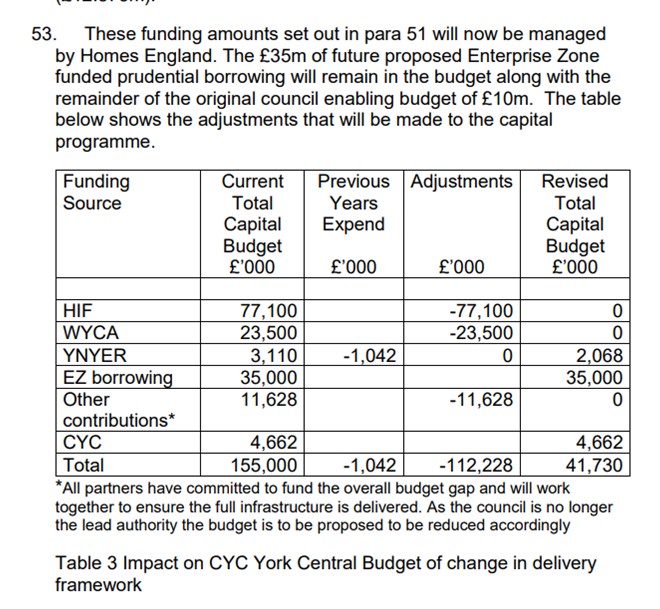
The existing nearby pedestrian crossing on Bootham will be upgraded and brought into the same control as the new signals. Three on-street car parking spaces on St. Mary’s to be removed closest to the junction to allow the stop-line to be set back into the street.
Face masks will have to be worn in shops from today. It remains to be seen how effective this government policy will be.
What is now clear is that some of the impulsive decisions taken a couple of months ago, at the peak of the pandemic by the York Council, have not met the test of time.
Tinkering with traffic systems without proper consultation or impact assessments was always a recipe for failure.
Crucially no attempt was made to define how success would be measured.
So how have they fared?
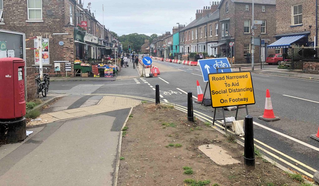
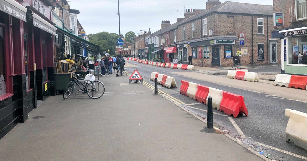
Bishopthore Road lane closure
This was intended to provide queuing space for shoppers. It was claimed that it would make social distancing easier.
Critics pointed to new hazards for cyclists on the contraflow lane, increased congestion & pollution on alternative routes and a missed opportunity to trial an off peak pedestrian area (10:30am – 4:00pm) approach.
The results have been disappointing with the alternative Nunnery Lane/Blossom Street/ Scarcroft Road suffering for increased congestion. Bus services have been adversely affected. There has been short cutting through residential areas like St Benedict Road where parking is also now a problem
There is little footpath queuing on the east of the shopping area. The forecourted shops on the other side have adequate space although bollards have reduced flexibility.
Verdict – scrap it
An ill considered scheme which missed the opportunity that part time pedestrianisation might have offered.
Fortunately there have been no accidents involving cyclists yet, although northbound traffic levels remain below average (as they do across the whole of the highway network)
Reduced social distancing requirements (now one metre rather than two) and the introduction of face masks should lead to this trial being abandoned. A more thorough consultation on the options for the Bishopthorpe Road area could then take place.
Bollards have not improved social distancing on Bishopthorpe RoadProblems with car parking and short cutting through the St Benedict’s Road area
Foss Bridge
One of the general traffic lanes across Foss Bridge on the inner ring road was repurposed for cyclists (southbound) . The lane had been coned off while maintenance work on the bridge was carried out in the early spring.
Most cyclists opt to use the riverside off road path. Comparatively few choose to use the inner ring road.
Verdict – retain and consult on its future
There has been little congestion on this section of the inner ring road although general travel patterns are not expected to return to pre COVID levels before September.
The cycle lane has been obstructed on occasions by delivery drivers, taxi pick ups etc. so the solution is less than perfect.
Vehicle numbers on this section of the inner ring road greatly exceed the number of cyclists
Monk Bar car park disabled spaces
The Council allocated 40 spaces at the Monk Bar car park for blue badge holders when additional access & parking restrictions were introduced in the City centre (e.g. Goodramgate). A “free” taxi service link to the rear of Kings Square is offered. The decision – like several others – was taken by the Councils acting chief executive with no prior consultation.
Blue badge holders can park on single yellow lines and park free of charge at Council car parks.
The little used taxi service is costing taxpayers £354 a day.
It appears that no attempt was made to assess the demand for disabled parking spaces at Monk Bar or for the taxi link. The Council didn’t specify the use of low emission vehicles on the taxi contract
Typically no more than five blue badge holders are parking at Monk Bar at any one time. The remaining general parking spaces are being increasingly used but the car park has yet to reach the full occupation levels seen before the pandemic. The Council has also recently allocated more on street parking spaces for blue badge holders in streets like Duncombe Place.
While the initiative was well intentioned, the Council hopelessly misjudged the demand for the service.
Verdict – revise the scheme
The number of reserved spaces can be reduced and the taxi link abandoned. Consultations can take place with disabled group representatives and traders on other options. These might include a “home to city centre” subsidised taxi service for the disabled where costs are recompensed when goods are bought.
Monk Bar blue badge spaces unusedNarrow access path at Monk Bar car park. No provision made for social distancing (see Maygate below)
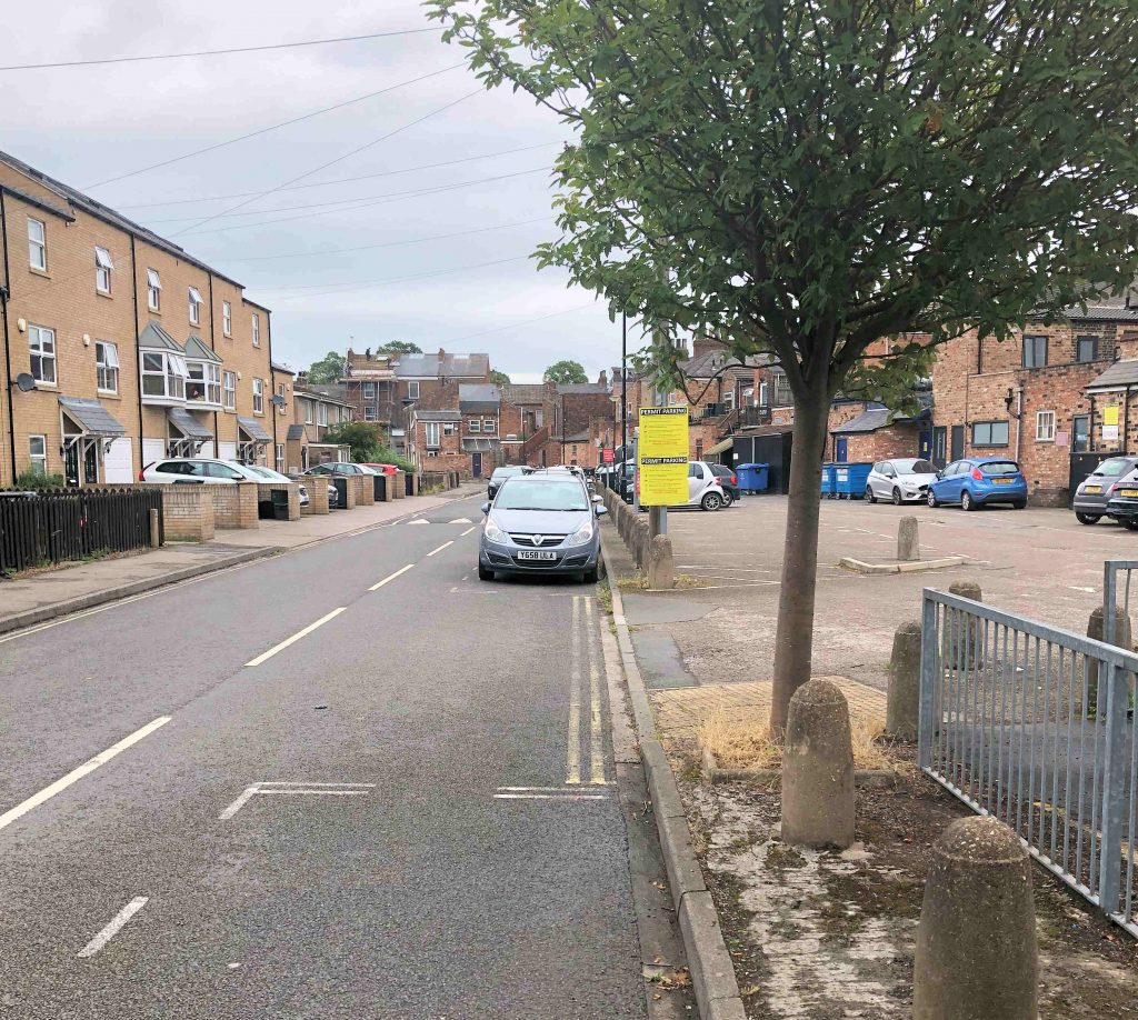
Marygate car park
Around 40 parking spaces have been cordoned off. The Council claimed it was to allow cyclists to avoid joint use of the footpath (which links Scarborough Bridge to Bootham Terrace). In turn this helped to maintain a two metre social distancing zone.
The scheme was criticised when proposed because if failed to assess the effectiveness of the obvious alternative (encouraging cyclists to use the internal car park service road) which would have involved the loss of only one parking space.
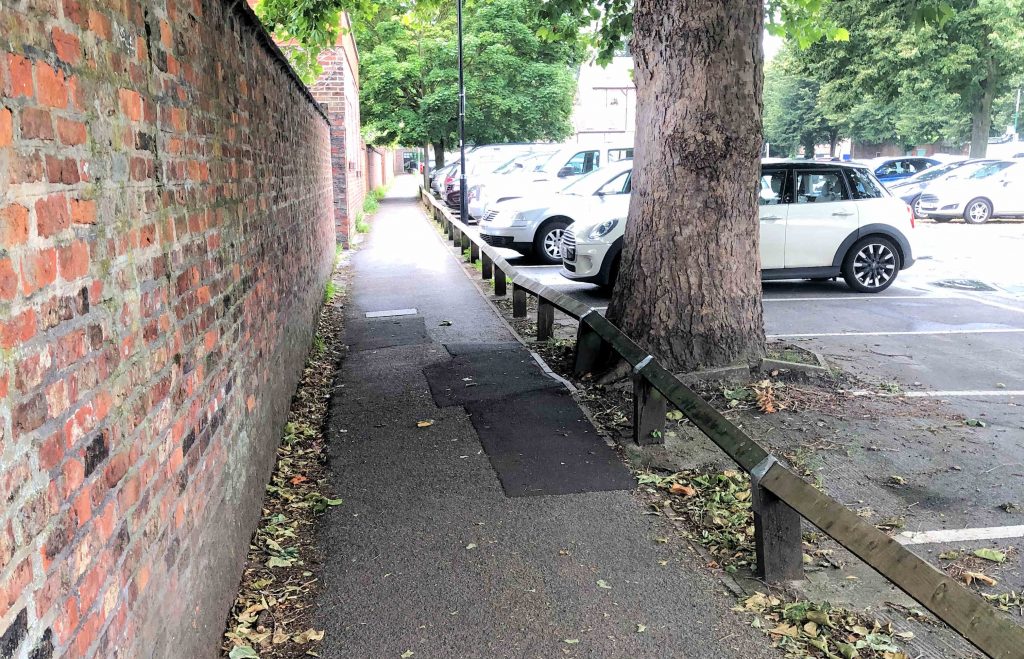
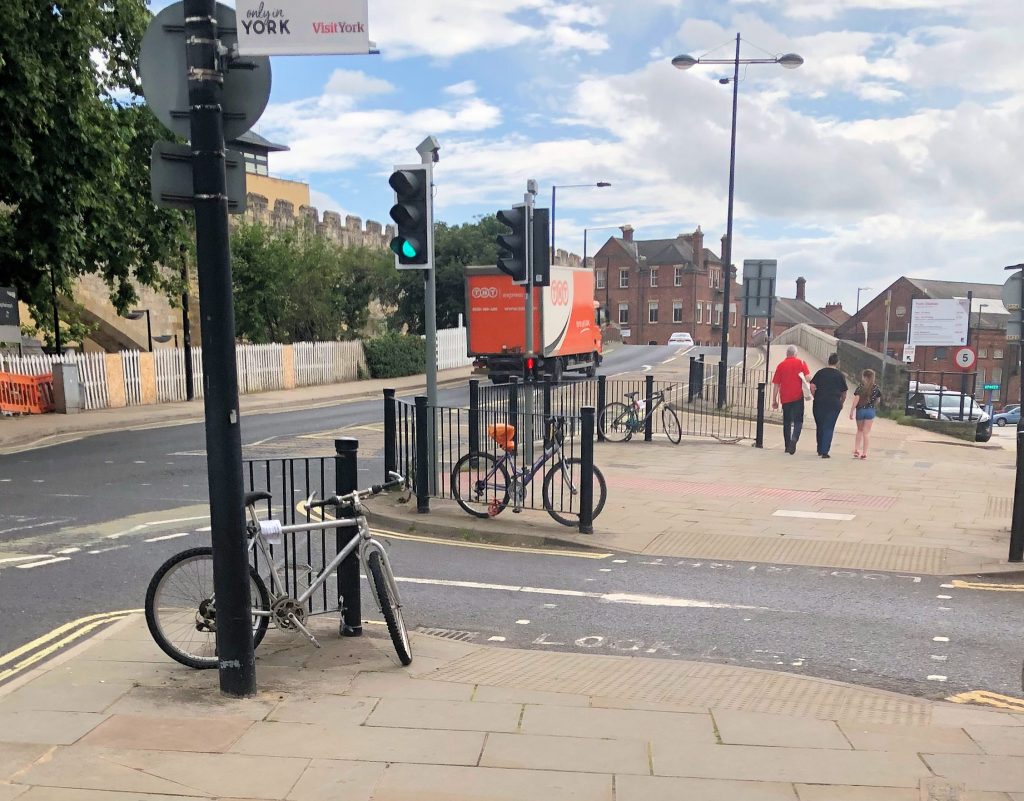
There were bigger problems on other routes from Scarborough Bridge both at the north (Marygate) end of the bridge and crucially at the station itself. A narrow tunnel connects the shared cycle/footpath to Bootham Terrace.
The introduction of one metre social distancing guidelines and the use of face masks will reduce any health threat.
Observations at the car park suggest that the cycle route through the parking spaces is very little used (with some cyclists opting to use the service road anyway).
The car park has been busy on occasions but has not yet reached capacity. This may change if August is as busy as it has been in the past
Verdict – amend the scheme to allow cyclists to use the car park service road.
There is no Coronavirus heath justification for routing cyclists through car parking spaces. The break in the perimeter fence can be retained – and one place bollarded off – to allow access via the service road to Bootham Tce and Almery Garth. A ramp to St Mary’s – promised but never delivered – would be a useful for both cyclists and disabled buggy users.
The Council should sort out an acceptable route for cyclists wishing to access the route from Scarborough bridge to Lowther Tce (long term plans for the station frontage remodelling need to recognise this demand)
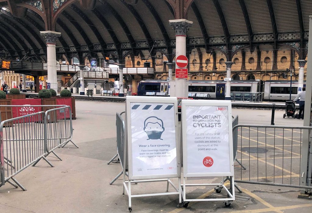
Conned off section on Marygate car park is little used by cyclistsNo cycling when you reach the station
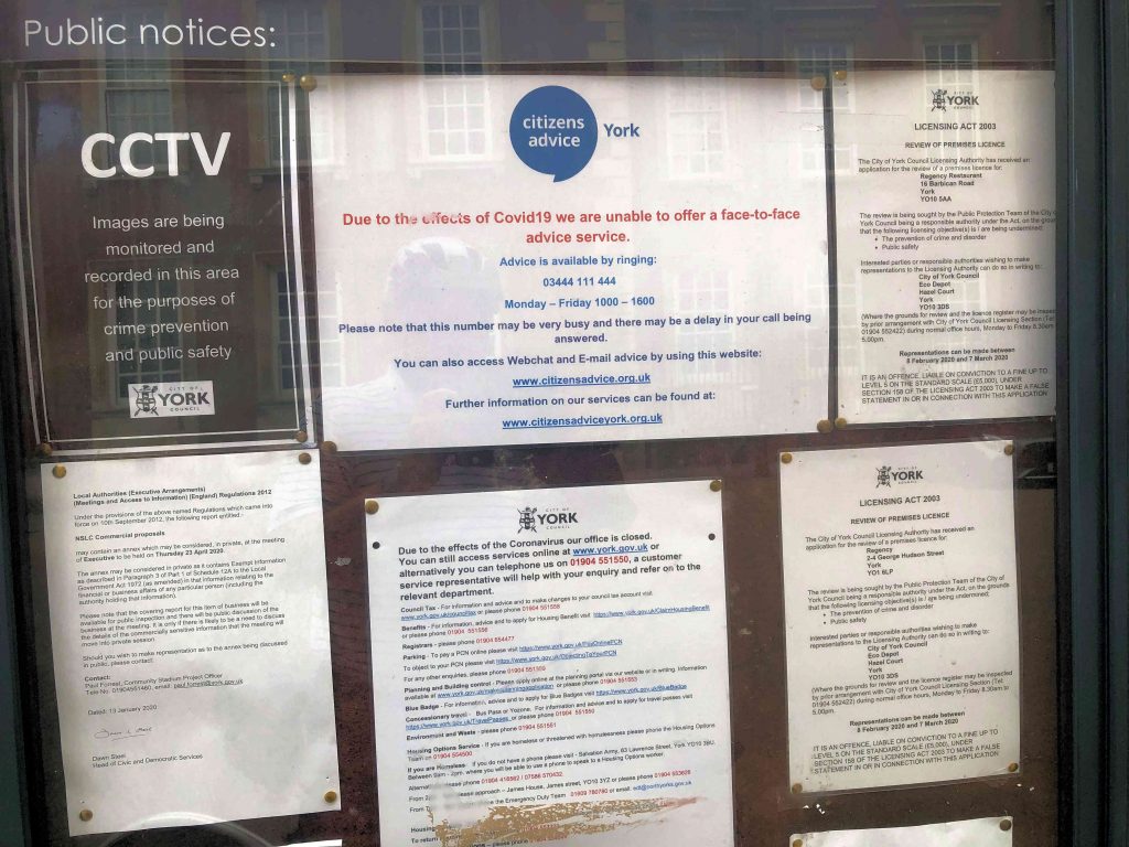
Few more on Spurriergate todayMuseum Gardens – with social distancing well organised by Museum staff – was popular todayMarygate car park close to capacity today apart from the completely useless coned off area. Not being used by anyone for social distancing. Meanwhile, at the other end of the Scarborough bridge cycle link to the station, cyclists wanting access the exit towards Holgate Road, have to dismount and walk through the congested portico or bus stop areas.Cycle parking still poor in York. These were chained to railings today. They had enforcement notices attached but, given the large sums of taxpayers money being thrown at some peoples idea of “sustainable transport”, installing a few extra parking frames (Sheffield stands) wouldn’t be amiss. The York Council offices are still closed. The gates are padlocked. Given the new government advice about “getting back to work” there should now be a road-map leading to the reopening of services where customers need personal contact. No information, forward plans or meeting agendas on Council, noticeboards. This one, outside West Offices, simply says that meetings are cancelled “until 30th May”. No noticeboards at all now outside the Guildhall. Although the building itself is closed for refurbishment, the noticeboards, previously displayed there, provided an easy, accessible location where residents could read about what the Council planned to consider. (Very few people routinely walk past the small noticeboard outside West Offices)
The York Central Partnership has submitted a planning application for the first phase of infrastructure works to unlock York Central
The plans include:
new access road for the site
bridge over the East Coast mainline
tree planting and landscaping
The York Central Partnership has submitted a planning application for the first phase of infrastructure works to unlock the York Central site and allow development to start, following extensive consultation held in February and March. The Partnership will now work, including through the planning process with City of York Council, to achieve a positive outcome in these exceptional times.
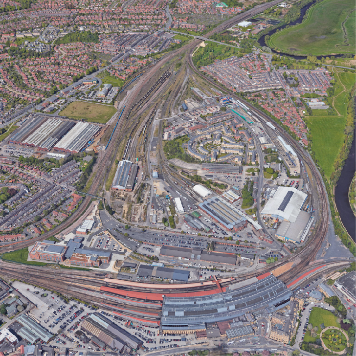
The partnership made up of Network Rail, Homes England, City of York Council and supported by the National Railway Museum is developing proposals to regenerate the 45 hectare site, one of the largest city centre brownfield development sites in the UK. This planning application will create the necessary access to the site, so that it can be unlocked to provide homes, employment opportunities, a new park and other facilities.
The first Reserved Matters application proposals include:
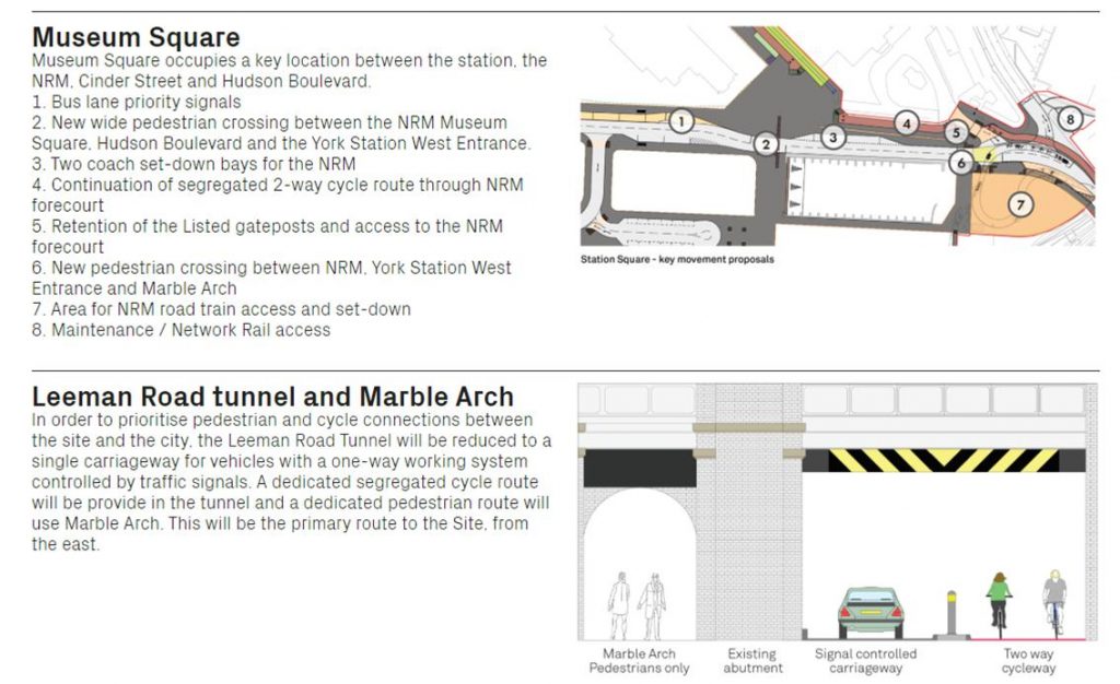
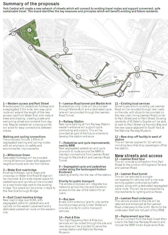
New access routes throughout the site, including 1.85km (1.1 miles) of segregated cycle and pedestrian pathways
A new bus lane on Cinder Street and routes for two park and ride services to run through the site
A new bridge in weathering steel, the same material is used on the new Scarborough Bridge foot and cycleway, across the East Coast Mainline
A £4m shared pedestrian and cycle bridge added to the Water End bridge
New streets and access points, including a Leeman Road link road, change to Leeman Road tunnel and Marble Arch
A new rail siding which will be used by the National Railway Museum
Mature tree planting along the routes, and new pathways and landscaping through Millennium Green
While the timing of any development is now likely to be impacted by the current lock-down, most concerns are likely to relate to the absence of a new dedicated cycle access in the Leeman Road tunnel area.
Leeman Road tunnel issues not resolved.
The current proposals involve a shared access route using the existing, sub standard, structure. One way working would impede public transport services.
There are similar access concerns for cyclists in the Wilton Rise area.
NB. The applicants promised to include the responses made by residents to their last public consultation, which took place in February, when they submitted this final planning application. They do not appear to have done so. Instead there is a sanitised version which fails to address many of the points made
The most controversial aspect is likely to remain the continued use of the Leeman Road (Marble Arch) tunnel for general traffic and cyclists. The proposers persist with the idea of reducing the carriageway to one – signal controlled – lane with cyclists using the other lane. They seem blithely unaware that neither the carriageway or pedestrian sections of the tunnel have a waterproof membrane. Quite simply pedestrians and cyclists will continue to face – in wet weather – an unpleasant introduction to what had been billed as a 21st century experience. Lack of forethought means that any link onto the Scarborough cycle bridge will also be awkward.
Marble Arch tunnel transport layout
There are few surprises in the rest of the package although those cycling from Wilton Rise might have hoped for more details of an alternative route to the existing archaic footbridge.
What to expect according to the Council
The Council has published the following media release, having leaked it to the commercial media over the weekend.
“City of York Council says it has unveiled proposals for the access routes which enable the York Central partnership to unlock the jobs, homes and public spaces developed through the award-winning Masterplan.
The council is working in partnership with Network Rail, Homes England and the National Railway Museum to develop proposals to regenerate the 45 hectare-site – one of the largest brownfield sites in the UK.
As the largest landowners, Network Rail and Homes England secured outline planning permission in 2019. This established the principles of the regeneration, creating up to 2500 homes, an estimated 6500 jobs, and a range of public spaces, including the city’s first new park in a century.
Each partner will now develop detailed ‘Reserved Matters’ planning applications covering different parts of the scheme. The council has prepared the first of these, in line with the outline planning application, as it is responsible for the funding and delivery of the essential infrastructure. Homes England and Network Rail are responsible for future applications for housing and employment space.
The first Reserved Matters application proposals include:
New access routes throughout the site, including 1.85km (1.1m) of segregated cycle and pedestrians pathways;
A new 3.5m wide bus lane on Cinder Street, and routes for two park and ride services to run through the site;
A new bridge in weathering steel – the material used on the new Scarborough Bridge foot and cycleway – across the east coast mainline;
A new 4m shared pedestrian and cycle bridge added to the Water End bridge;
New streets and access points, including Leeman Road Spur, change to Leeman Road tunnel and Marble Arch;
A replacement rail link which will be used by the National Railway Museum;
Mature tree planting along the routes, new pathways and landscaping through Millennium Green”.
Councillor Keith Aspden, Leader of City of York Council, said:
“York Central has enormous potential to deliver a wide-range of benefits to the city, including new homes, new jobs and new sustainable transport links in the heart of the city.”
“Together with our partners, we have placed public engagement at the centre of our proposals to provide the homes, jobs and public spaces which the city needs. We are sharing these plans to demonstrate how we have responded to what residents have been telling us, particularly with regards to pedestrian, cycle and bus routes.”
“I would strongly encourage everyone to look and engage with these proposals, as it is incredibly important to us that the York Central development happens and works to the benefit of everyone in the city.”
People can see the proposals from Monday 24 February in several ways:
New off road vehicles are set to be used to grit 11miles (18km) of York’s cycle network this winter.
If successful, the pilot could be extended across the city to help keep cyclists safer in winter conditions.
A report detailing the pilot will be taken to a public meeting on Thursday 19 September, for approval to start during the winter season between November and March.
The pilot includes using two different vehicles to grit 11miles (18km) of cycle network, using small all-terrain vehicles including a quad bike and a gator type machine.
The trial is welcome but rather distracts attention from other more pressing issues facing cyclists.
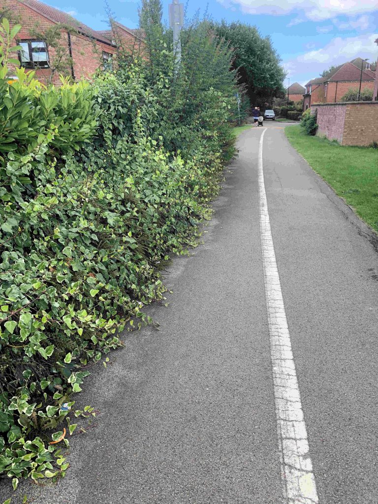
Many cycle paths in the City are obstructed
Many cycle paths are currently obstructed by overhanging hedge and tree branches. Unchecked weed growth has also reduced path widths as has the failure of the Council to systematically “edge” verges.
Perhaps the most pressing issue though is potholes. These affect some cycle lanes and many inner sections of carriageways – the surfaces most used by cyclists.
It is now 10 years since the last major programme of cycle margin maintenance works took place in the City.
The Council says that, “Popular cycle routes have been chosen for the de-icing trial, including the new Scarborough Bridge and other off road bridges too.
The introduction of the new smaller vehicles will ensure the networks are effectively gritted. Off road cycle networks are often difficult to grit or salt because cycles don’t have the same weight or action as a vehicle tyre. Effective gritting works by vehicles driving over the grit with their tyres which beds the grit into the snow and ice.
Whilst cars or heavy vehicles generally follow the same tyre path. Cycle tyres are much thinner and therefore these typical treatments are less effective.
For the pilot, the council will hire the vehicles and if, following the pilot, the council decides to roll this scheme out across York, it will look to purchase new vehicles to the council’s fleet.
The cost of the pilot is estimated to be £42k. This will be met by the current winter maintenance budget which is £401k.
By its nature the winter maintenance budget is not predictable, in 2018/19 there was an underspend of £61k. Should this not occur in 2019/20 there is a winter maintenance contingency available of £258k, in addition to the annual budget, which could be utilised.
This pilot will not formally be part of the council’s Winter Service Plan, but will run alongside this a pilot. After the winter the pilot will be assessed and considered for formally incorporating into the Winter Service Plan”.
Preparing for the winter season:
The council has stockpiled 3,000 tonnes of grit, which is stored in its grit barn at Hazel Court depot.
On average, crews spread around 4,500 tonnes of grit per season, over 75 road treatments (gritter runs).
Each season, crews treat eight routes across the highway, covering 365km of York’s road network, including 22km of priority footpaths and, when recourses allow, 58km of cycle network.
The decision session takes place on Thursday 19 September at West Offices from 2pm and is open to members of the public or is available to watch later online from: www.york.gov.uk/webcasts
City of York Council’s full council declared a climate emergency in March 2019, and agreed to set a target to become net carbon neutral by 2030.
A report is now being taken to the council’s Executive to provide an update on the next steps to progress the climate change action plan.
Following the climate emergency declaration, a new cross-party climate change policy and scrutiny committee was created to help develop the climate change action plan. Its first meeting will take place in September (and every other month after that).
The council is in the process of recruiting officers to two new posts to address sustainability and climate change to support on this work.
A report detailing the next steps will be taken to a public Executive meeting on Thursday 29 August.
York has a strong history of taking the lead on reducing carbon useage, including:
£2m programme of LED street lighting;
Solar PV installed on 541 council houses;
Air source heat pumps installed in 57 council houses;
A programme of cavity wall and loft insulation across the council’s housing stock;
Work with private tenants and homeowners to draw on funding from Government and regional programmes for improved energy efficiency and delivered through Better Homes Yorkshire;
Plans to use an innovative water-source heat pump for heating the redeveloped Guildhall complex;
Council support for the Treemendous initiative to plant 50,000 trees in York;
Investment in improvements to cycling infrastructure including the recent opening of the Scarborough Bridge cycle route and promotion of cycling – including achieving Cycling City status;
The i-Travel programme which includes active promotion of walking, cycling and sustainable travel options to groups and individuals.

 The design for a wider shared-use pedestrian and cycle bridge at Scarborough Bridge was unanimously endorsed by the council’s Planning Sub-Committee yesterday.