City of York Council has submitted more information about the definition of the city’s green belt to the Planning Inspector examining the local plan.
The council submitted the explanation of how it defines the outer boundary of the green belt, with explanations of other green belt boundaries set to follow. Officers also issued the timetable to deliver all the remaining additional information requested by Government inspectors by the end of April.
Having received the bulk of this information in December and January, inspectors have previously indicated that the examination is likely to progress to online consultation over the new information, followed by further hearing sessions, most likely to be held in summer at the earliest.
UPDATE – New representations have now been made by the York Council to the Planning Inspector. They can be viewed by clicking here
The latest exchange of correspondence, between planning inspectors appointed by the government and the City of York Council, on the proposed “Local Plan” simply serves to highlight how difficult it is to produce a robust proposal which can stand the test of time.
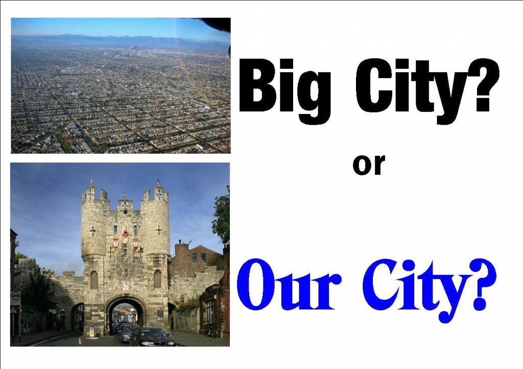
Controversial plan was to have been determined in February 2019.
The latest exchange concerns apparent lack of justification for the Green Belt boundaries. These heavily influence the size of the area allocated for new housing in the City.
It is not a new argument.
It is nearly 20 years since York embarked on an attempt to update its strategic plan. It came close to success in 2011 when aproposal was ready to be sent off to the planning inspectorate.
Of the five drafts that have seen the light of day, this was perhaps the one which achieved the broadest consensus. It envisaged building an additional 575 homes in the City each year for 30 years
In the main it was some developers and the political fringe who objected to it.
A change of political control saw an inexperienced Labour administration adopt a newproposalwhich would have seen the City increase in size by 25%. The stance contributed to them being booted out of office 4 years later.
Anotherattempt was made but was again jeopardised by the unexpected(in this case the decision to close barracks in the City).
It would be 2019 before the revised plan was ready to be submitted.
It still included a higher growth rate for housing than was necessary to sustain the existing City. It anticipated large amounts of “inward migration” to fill the extra jobs and homes that were envisaged. But again, changing government policies, unstable population growth forecasts and then coronavirus combined to halt the final “examination in public” part of the process.
Now the inspector wants the Council to withdraw its proposals and start again. That would mean more delay, plus expenditure of another £x million for taxpayers with no guarantee that a plan would be approved at the end of the process.
Planning inspectors are paid a fee of around £1000 a day! Some may feel that they have a vested interest in prevarication
The Council has opted to try to provide more information to move things forward.
There are vested interests at work for whom delays are an advantage.
Lack of a strategic blueprint means that developers can chance their arm by submitting planning applications on wholly unsuitable sites in the Green Belt. Schemes at Moor Lane and Boroughbridge Road are recent examples.
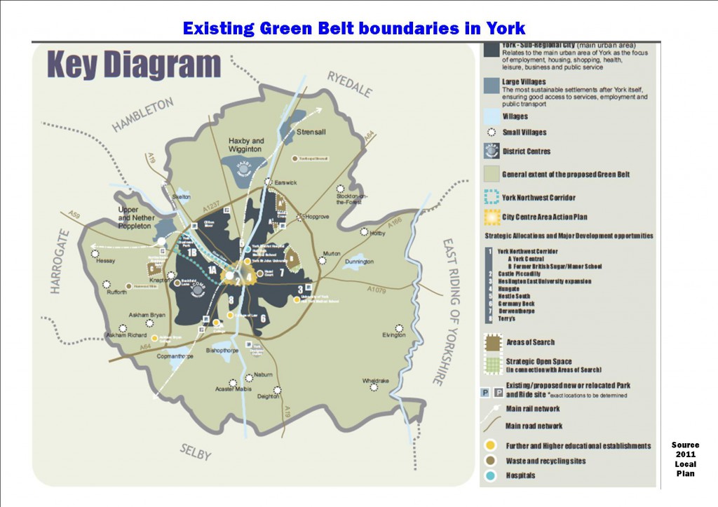
Existing York Green Belt boundaries.
Getting a Local Plan adopted is pretty much impossible given the current high level of central government interference.
The City needs to be able to get on and determine its own future. The ballot box provides a safety net against the adoption of extreme policies.
What will happen, before the detached hand of a North Yorkshire Mayor tries to seize the reins of power, remains to be seen.
Hopefully the Council and the planning inspector will now find a way to move forward more quickly.
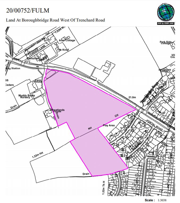
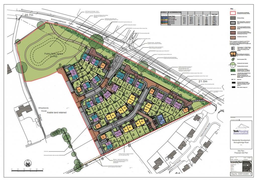
1.1 The site occupies part of an agricultural field on the south side of Boroughbridge Road (A59), positioned at the edge of the suburban area on the west side of the city.
There is housing to the east; Trenchard Road being closest, and Muddy Boots nursery to the west of the site.
Beyond the site, there is further agricultural land to the west and then a petrol station and commercial unit positioned at the junction where the A59 meets the outer ring road.
To the south is agricultural land between the suburban edge and the outer ring road.
Opposite the site on the north side of the A59 is the former Civil Service site, which has planning permission for housing development (266 dwellings approved under application 14/02979/FULM).
The site is within the general extent of the Green Belt.
The development plan for the area is the Upper and Nether Poppleton Neighbourhood Plan. Within the plan the site is designated as being within the Green Belt.
The site is also within land identified as Green Belt in un-adopted local plans – the 2005 Draft Local Plan and the 2018 Publication Draft Local Plan (DLP).
The application proposes 60 dwellings, with a single access point for vehicles from the A59 and associated public open space in the centre of the site and opposite the A59. The vehicle access would be opposite the approved access for the housing site at former civil service site.
The application(click) is recommended for refusal at a meeting which is taking place on 3rd December.
NB. The same meeting will have a second go at determining a planning application for the Castle Mills Car park site. This is a proposal from the Council itself and was deferred to allow further input from the professional advisers. It would see 106 apartments built and is recommended for approval.
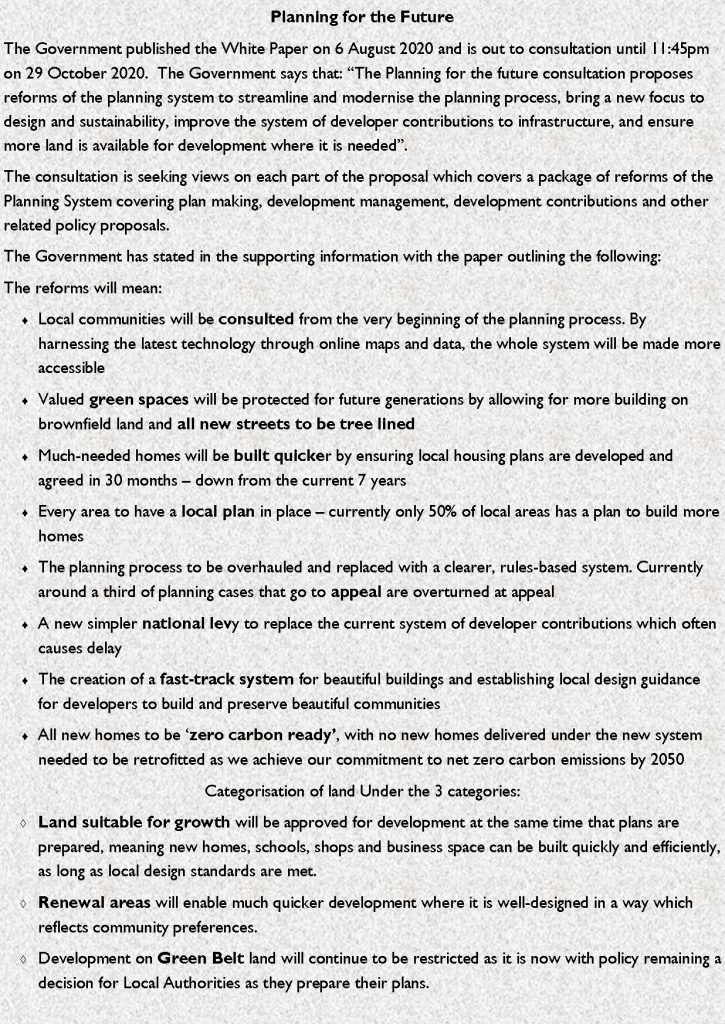
The York Council will consider next week itsreactionto controversial changes to planning laws being promoted by the government.
Although some of the proposals will be welcomed – they include commitments to green space and tree planting – other look set to reduce the amount of influence that local communities have on what is built in their area.
Government claims
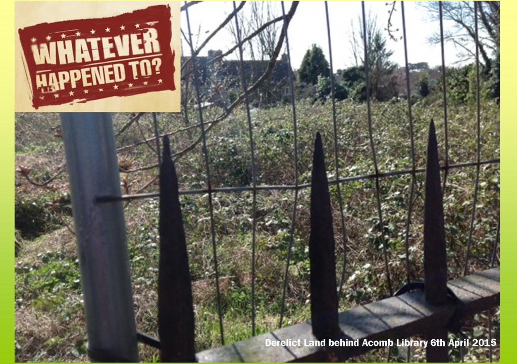
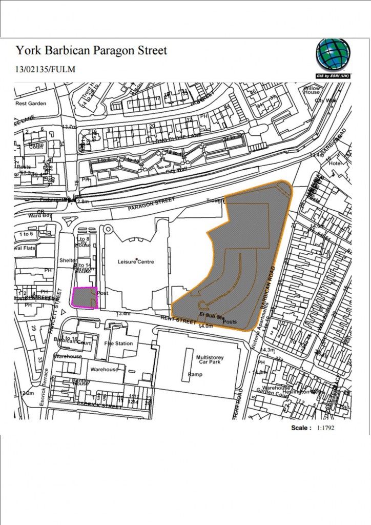
The government also seems to be willing to address the problem of delays on sites which already have planning permission (e.g. the British Sugar site on Boroughbridge Road) and other derelict sites that developers have put in their “land banks” (e.g. the site next to the Barbican).
Derelict Council land
There are no proposals, however, which would force Local Authorities to release unused land and empty buildings for reuse.
But the general drift away from community control on planning applications will be seen by many as a step in the wrong direction. Zoning land for “Growth” (areas suitable for substantial development), “Renewal” (areas suitable for development), and areas that are “Protected” (e.g. Green Belt) simply ignores the knock on effect that the scale and timing of development can have on a local community .
Derelict land next to Barbican
The proposal also sets the percentage of affordable homes which must be provided in new developments of over 50 homes, and how they will be allocated (first time buyers will be offered 25% of them)
The proposals will allow retail premises to change to offices, or vice versa, without the need for planning permission.
Existing legislation allows for permitted development rights to be used which facilitate the conversation of existing offices to residential units.
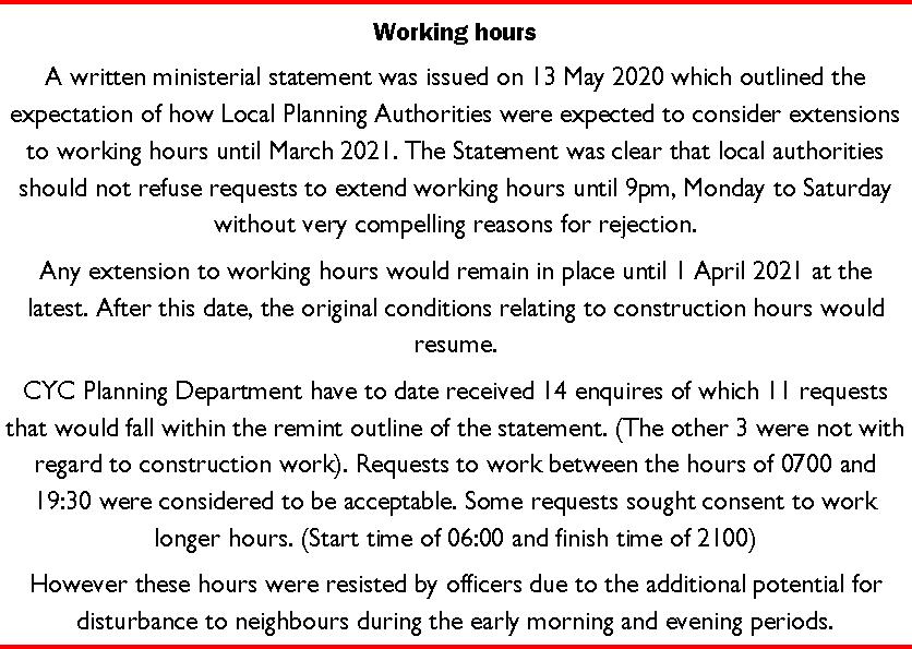
The report also confirms that 14 developers in York have applied since March to extend the working hours on their sites. The concession will end in March 2021.
Residents can respond to the consultation via this link (click).
Government inspectors have written to the York Council highlighting issues with the methodology used to establish the detail of the York Green Belt boundary.
They have however confirmed the general boundaries to be those defined in long standing regional strategies
The main issue – the number of additional homes required in the area – still remains open to criticism. Population growth estimates have gradually reduced in recent years although the Councils plan still seeks to allocate sites for 20,000 additional homes. The impact of the coronavirus scare is expected to further reduce house building demands in the City.
The examination itself has been held up during lock-down and it remains very unclear when, or even if, it will recommence.
The letter, which has been published by City of York Council today, follows examination hearings on several key aspects of the plan, including the duty to co-operate, housing numbers and the spatial strategy and Green Belt issues. The letter invites a response from the Council on aspects of the approach it has taken to define York’s Green Belt boundaries.
The Council says “it has already begun this work and has formally responded to the planning inspectors to thank them for their work so far. To progress the Local Plan, City of York will continue to work with the planning inspectors to justify the approach taken to define York’s greenbelt boundaries”.
“The proposed plan looks to deliver over 20,000 homes over the next 20 years, including up to 4000 more affordable homes, and prioritises development on brownfield sites. The plan will also create around 650 new jobs per year, whilst crucially defining the greenbelt boundaries in planning law for the first time since the 1950s”.
The draft Local Plan was submitted to the Secretary of State on 25 May 2018. Since submission, there has been ongoing correspondence between the Council and the Inspectors.
Phased hearing sessions started in December 2019. This phase focused on legal compliance and in-principle matters relating to York’s housing requirement, spatial distribution and approach to Green Belt.
Today’s announcement of a plan to build on greenbelt land between Acomb and Poppleton highlights the problems that lockdown is bringing for the planning system in the City.
An application for a major new development on Boroughbridge Road has been submitted.
The Councils Local Plan never got beyond the preliminary stages of a hearing in public before restrictions caused proceedings to be suspended.
As so much of the Plan depends on – now impossibly unrealistic – assumptions about economic growth and the demand for extra housing that will bring not surprisingly some objectors are calling for a new plan to be developed.
But that would leave the City without a basis on which to judge individual applications for a period of 5 years or longer. It would also involve enormous cost which the taxpayer can ill afford. It isn’t even certain when revised ONS population figures could be published reflecting what is now called he “new normal”.
The “new normal” won’t be clear for at least a year.
Against that background, some developers are spotting the main chance and seeking to exploit the chaos in the planning system. Losing large chunks of the Green Belt to avarice would be a disaster for the City.
The Council only has itself to blame. They bounced their own Lowfields development – much of which is being built on playing fields – through the system before it could be subject to a proper public inquiry. The Council may, therefore, find it difficult to defend its position, if significant numbers of appeals are lodged against planning applications even if they have been rejected locally.
This also raises the issue of the role of the planning committee.
At least on “meeting” of the committee will be held later this month (21st May at 10.30am) to consider an application at the hospital. Many of its members will not be allowed to participate in what will be a “remote” meeting.
Instead what the Council terms a proportional sample will make decisions (Cllrs (Cullwick, Chair, Pavlovic, Vice Chair, Ayre, Hollyer, Perrett, Kilbane and D’Agorne). The “proportion is based on the relative strength of the political parties represented on the Council. However planning decisions should not be determined by party political priorities. Each application should be judged on its merits.
Several Conservative and Independent members are therefore being excluded from the process, ostensibly on the basis that the more who log in the greater the risk of technical failure.
It may be that the hospital application will prove to be uncontroversial. The only outstanding application is for the erection of vascular imaging unit on Wigginton Road. The application was submitted last August. The only significant issue appears to relate to drainage.
But there are other controversial proposals in the pipeline. The Acomb/Poppleton proposals may be the tip of the iceberg.
A more inclusive way of making decisions is required.
NB. We were sorry to learn of the passing recently of Rachel Macefield who was the lead planning officer for the Council on the York Local Plan. Our condolences to her family and friends.
The Planning committee is being recommended to refuse planning permission for the erection of 516 houses on Moor Lane near Woodthorpe.
The applicationcaused an outcry last year because of concerns about its effect on the nearby Askham Bog. A host of celebrity experts lined up to oppose the plan. They pointed to the disastrous effect that changes to the hydrology in the area could have on the Site of Scientific Interest.
The report describes the existing site.
“The application site extends to approximately 40.5Ha of
farmland to the South of Moor Lane in Woodthorpe approximately 3.5km from the
city centre. The farmland is divided by mature hedges, trees, a number of farm
tracks and field drains. Marsh Farm sits within the centre of the site and
consists of a farm house with a mixture of period and modern barns”.
The site is shown as Green Belt in the latest York Local
Plan. This plan will be subject to a public examination over the next few
weeks.
The need to preserve the Gren Belt boundary in the area
forms the basis for the likely refusal of the application. However, concerns are
also expressed about traffic generation from the site as well as other issues
Objections to the application were raised By Natural England,
Historic England and the Yorkshire Wildlife Trust (who manage the Bog site). A
wide range of other organisations and local Councillors have objected to the proposal.
There were also 401 individual letters of objections and 7210 emails!
The Planning Committee meets to determine the application on
Thursday 11th July at 4:30pm.
If the application is refused, the developer has a right of appeal to the Secretary of State.
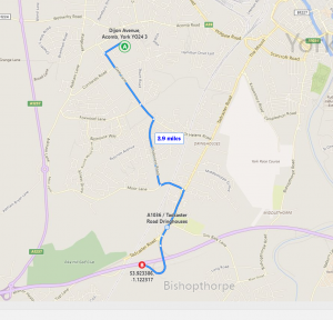
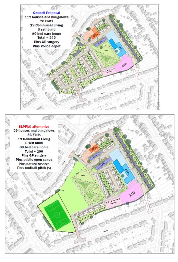
2.9 miles from Lowfields to “replacement” football pitch
In a planning committee report, officials are still claiming that the Woodthorpe Wanderers Football team will relocate from the Lowfields sports field to a new pitch being created on the Green Belt near London Bridge on Tadcaster Road.
Residents had understood that this had been ruled out as too remote and lacking in perimeter security. The Club does have access to the nearby college pitch.
The London Bridge field may, however, meet the needs of the Bishopthorpe football club.
The fate of the Lowfields football pitch is central to plan to build houses at Lowfields.
The Sports Council have objected to the loss of the facility.
The Council has now said that they will consider the planning application at their August meeting, well ahead of the start of the Public Inquiry into the York Local Plan.
There have been a lot of objections to the Local Plan relating to the development of the playing field.
Not surprisingly local amenity bodies are crying “foul” over the timing of the planning applications. The Lowfields Action Group have updated their Facebook page.
A few months ago the Action Group published an alternative layout for the Lowfields site which would have ensured that the pitch was retained while also providing space for 200 homes.
Alternative proposal for Lowfields tabled by residents
There are some serious implications for existing Council tenants within the “housing development programme” published by the Council today. We’ll comment on these later in the week.
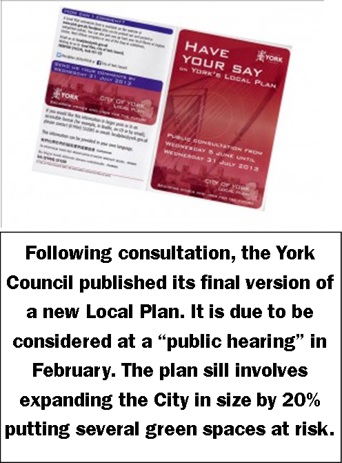
There are only a few days left for residents, businesses, developers and landowners to help shape one of the most important strategies of our generation, by having their say on the Local Plan sites consultation.
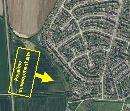
Developers are eyeing land at the end of Grange Lane
City of York Council is currently preparing York’s Local Plan, which will support the city’s economic growth, protect York’s green belt, address the shortage of housing and help shape future development and employment in York over the next 15-years and beyond.
On the west of the City there are a number of controversial proposals notably the plan to build on the playing fields at the former Lowfields school site.
Residents don’t, of course, know what alternative proposals developers are suggesting although one – development of the land a the end of Grange Lane – has become public.
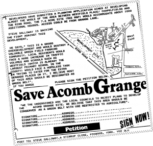
Extract from Focus newsletter 1988
Ironically it is almost exactly 28 years to the day since a proposal to develop land near Askham Grange was first mooted.
At that time, local Councillors were able to successfully fight off the threat and the land has remained in the Green Belt ever since.
The eight-week consultation finishes on Monday 12 September at 5pm on the Local Plan Preferred Sites document, which outlines revised figures for housing, employment and sites.
Go online: http://tinyurl.com/LPGrange to complete the survey and to find a full copy of the Local Plan Preferred Sites document
According to papers seen by Ward Councillors, a developer is still hoping to build on land at the top of Grange Lane. The news came only days after the Council announced that all existing Green Belt land lying between the built up area and the A1237 northern bypass would continue to be protected.
The confirmation of the existing Green Belt boundaries was made possible after the LibDems identified sufficient “brownfield” (previously developed) land to meet housing needs for the foreseeable future.
In total around 12,000 additional homes will be provided over the next 20 years under the new Local Plan
It means that building works will be concentrated on sites like the rear of the railway station.
However developers can appeal against this decision and they may have the support of the Labour party which originally tabled proposals which would have seen the City increase in size by 25%.
Local Councillor Andrew Waller has criticised the Grange Lane plans.
“Development on this site would exacerbate traffic problems in the area which are already acute at school arrival and leaving times.
The fields between Chapelfields and the ring road provide a soft boundary between the open countryside and the City and include some informal recreational walks.
They shouldn’t be sacrificed so a private individual can make a quick profit”.
“I hope that residents will write to the Council supporting the existing Green Belt boundaries”.
Response forms are available on the Council’s website (www.york.gov.uk/localplan ) or are available from the Council’s West Offices reception or from Acomb library.


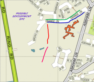
 According to papers seen by Ward Councillors, a developer is still hoping to build on land at the top of Grange Lane. The news came only days after the Council announced that all existing Green Belt land lying between the built up area and the A1237 northern bypass would continue to be protected.
 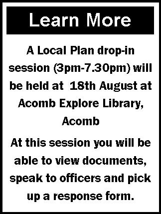 “Development on this site would exacerbate traffic problems in the area which are already acute at school arrival and leaving times.