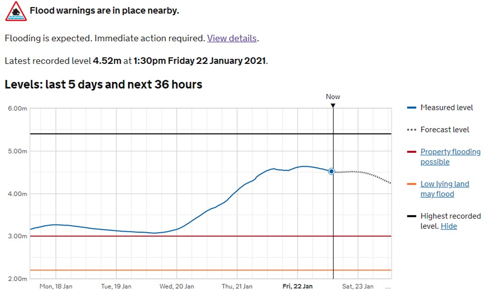
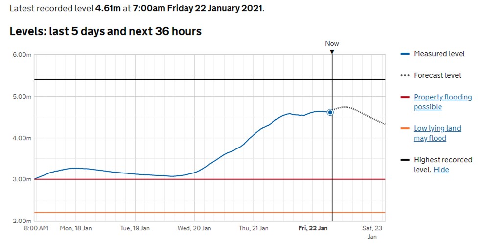
The level of the River Ouse now appears to have peaked. It should return gradually to normal levels over the next few days, although some additional snow and rain is forecast.
Think we can safely say that it may be some time before Naburn fully dries out
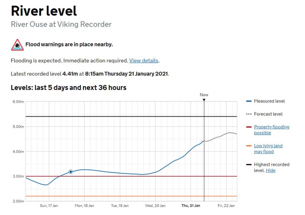
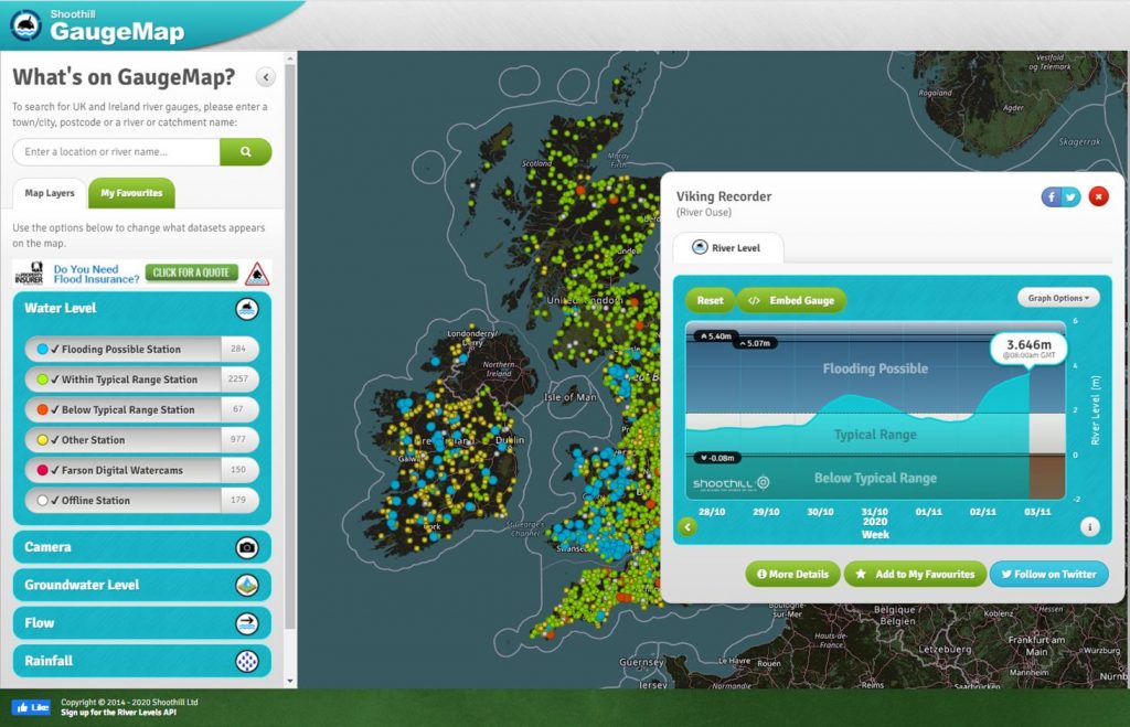
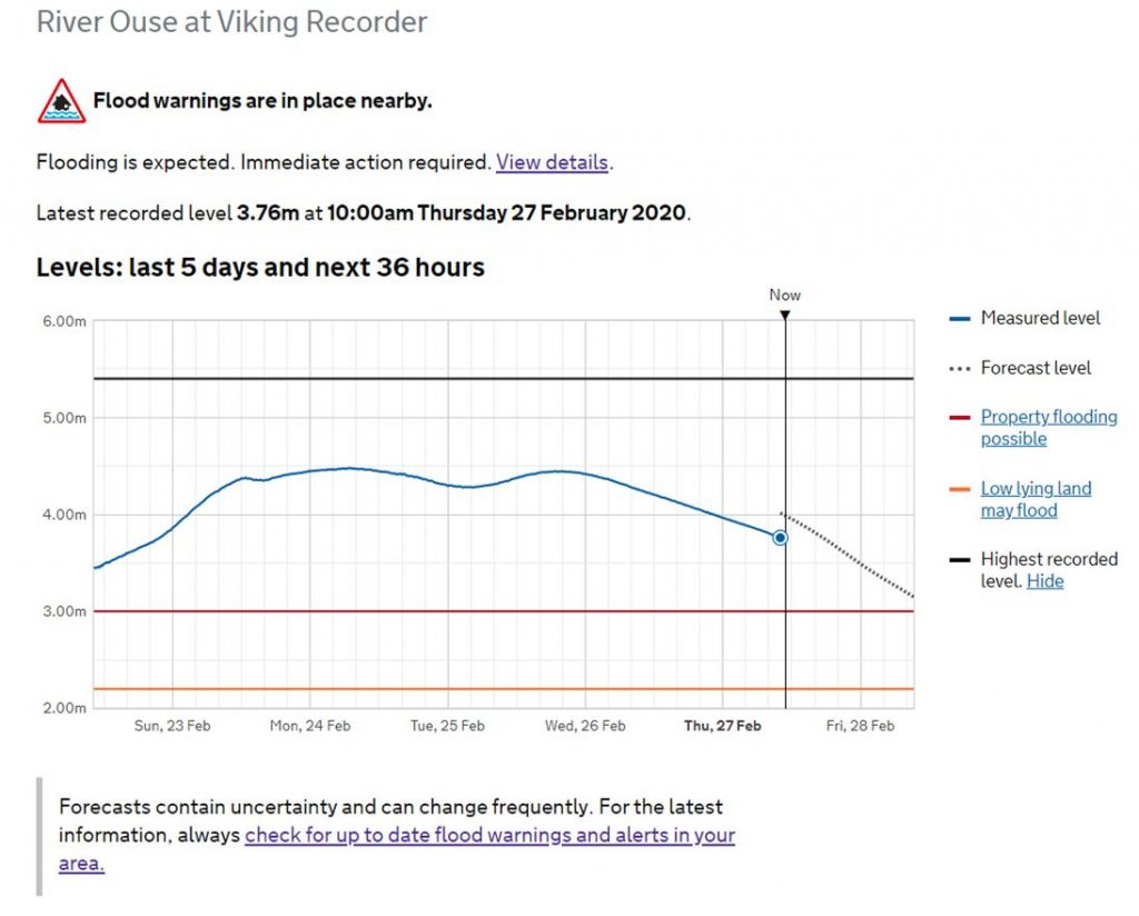
The revised highest level forecast for the River Ouse in the next 36 hours is 4.74m at 12:30pm Friday 22nd January 2021.
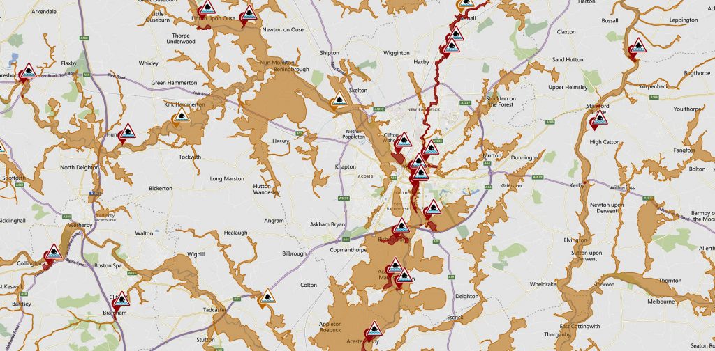
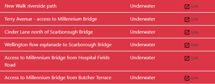
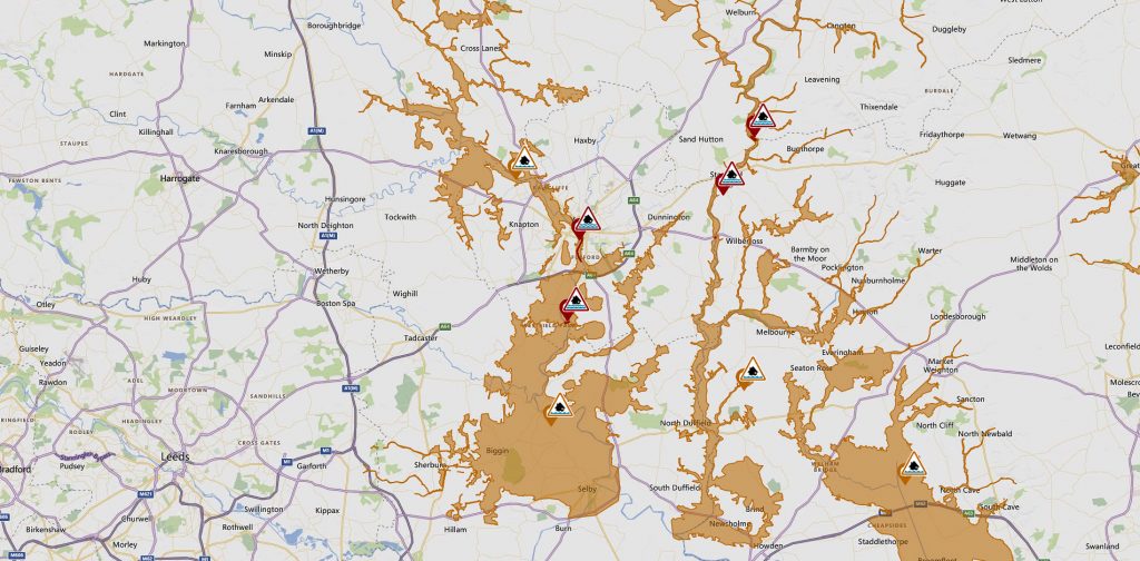
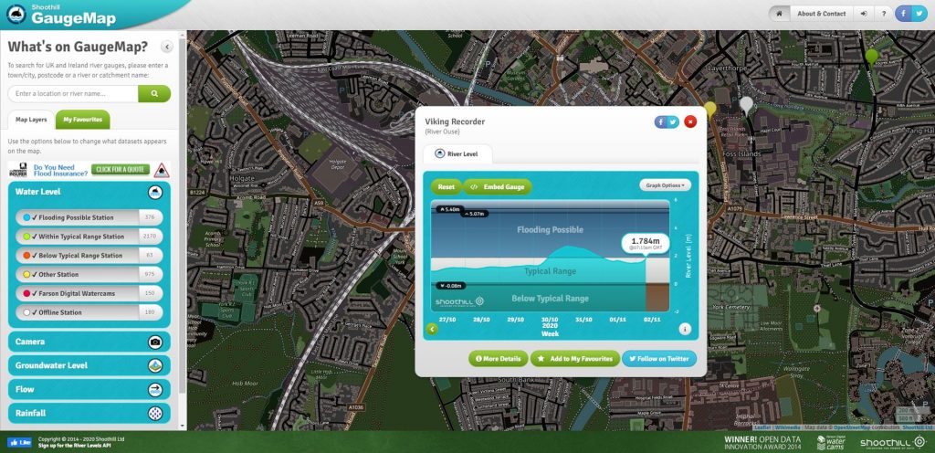
Several areas in York may be subject to flooding during the next 24 hours. Click on the graphic for updates
Flooding mapKings Staithe live cam. If the top of the no entry sign submerges then properties are likely to be floodedThe highest level forecast in the next 36 hours is 4.75m at 2:30am Friday 22 January 2021. Highest level recorded at this location was 5.40m
Above 2.20m flooding of low-lying land may occur in these areas
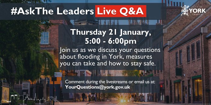
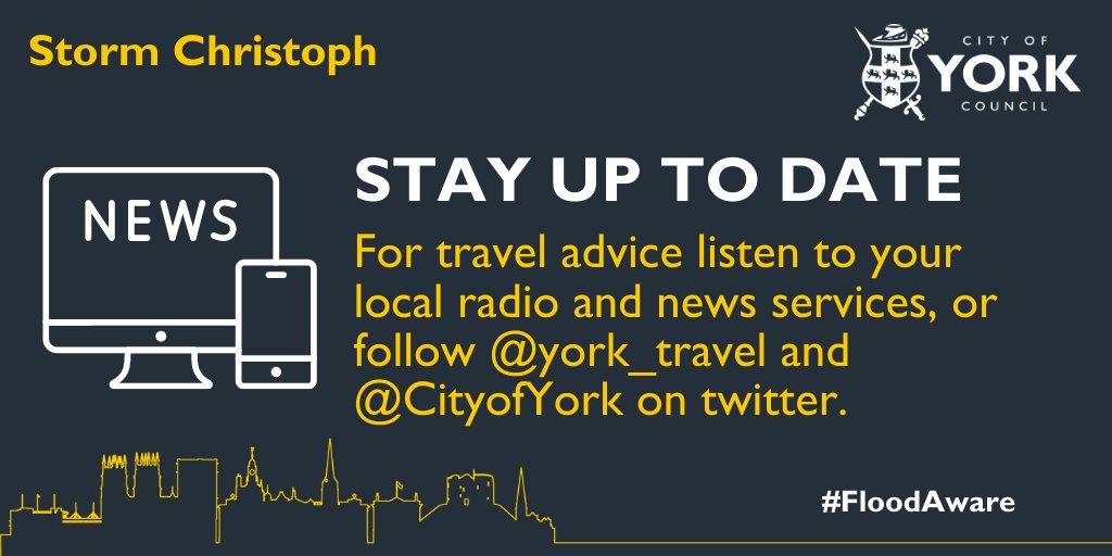
LIVE Q&A TONIGHT With river levels expected to peak between 4.4 and 4.8m tonight our #AskTheLeaders session will focus on answering your questions about flooding. E-mail your question in advance to YourQuestions@York.gov.uk or ask them live on our facebook live steam.
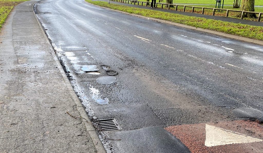
The ice and snow has largely disappeared from York today.
In its place are a new – and not so new – crop of potholes.
Please help to make the City safer by reporting any that are a danger to road users.
Potholes on Foxwood Lane are multiplying.
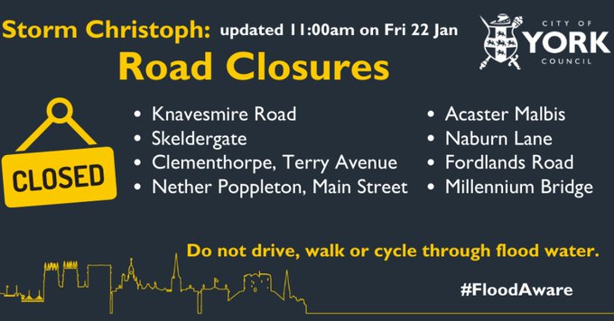
The next problem we are likely to face is flooding. Three Flood Warnings are already in place for the City.
It will be two or three days before the snow melt in the Dales & Moors catchment areas reaches the City.
Progress can be viewed by clicking the image below.
Surface water drainage seems to be less of a problem at the moment.
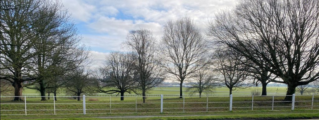
The Knavesmire flood works seem to have reduced the standing water problem which was a feature of most winters until recently.
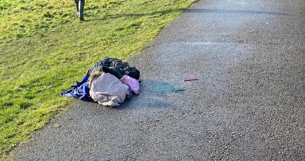
Impromptu village pond appearing on Little Hob Moor. Knavesmire largely clear.We’ve reported some rubbish which was revealed as the snow melted, including this black bag on Hob Moor.
City of York Council and partners are putting in place flood defences to ensure York residents and businesses can get on with ‘business as usual’ despite river levels rising after Storm Bella.
With river levels predicted to peak at around 4 metres in the early hours of tomorrow (Monday 28 December 2020), the council has acted early to put in place defences to protect those areas most affected.
Sandbag barriers are being constructed at Clementhorpe, Tower Gardens and Tower Street, together with a pump to clear water, while flood boards have been installed at Peckitt Street.
St George’s Field Car Park will be closed today.
Rowntree Park will remain open today until 4pm, but will be closed tomorrow.
Riverside paths in the city and access roads in Poppleton and Naburn will be affected.
Any residential properties likely to be affected are resilient to flooding at these levels, but residents are advised to follow their personal flood plans.
With no more rain predicted today, the river level is exected to slowly decline after peaking in the early hours of tomorrow. The council will not be issuing sandbags to properties unless the forecast levels rise.
Council has teams on standby to support residents and businesses in a COVID- secure way as river levels set to peak
Minor flooding of riverside paths has occurred over night. (click)
Click for update
City of York Council has front line teams on standby to support residents and businesses as river levels are set to peak on Wednesday 4 November.
The council is working with the Environment Agency and will use the latest advice to identify peak levels and will communicate any potential impacts separately.
Letters are being sent to residents living in homes and properties which might be directly affected by high river levels, which provides advice and support as well as the measures being put in place.
The council is working closely with the York and North Yorkshire Local Resilience Forum, which includes police and fire services as well as North Yorkshire County Council, Met Office and Environment Agency.
View the latest river level predictions and warnings here.
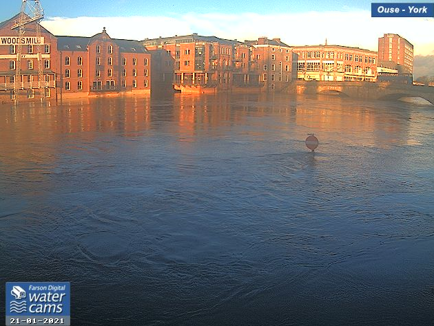
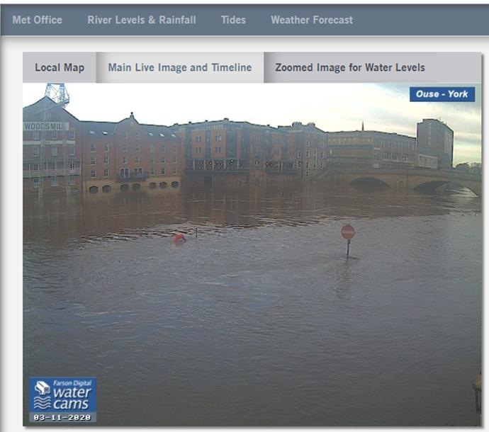
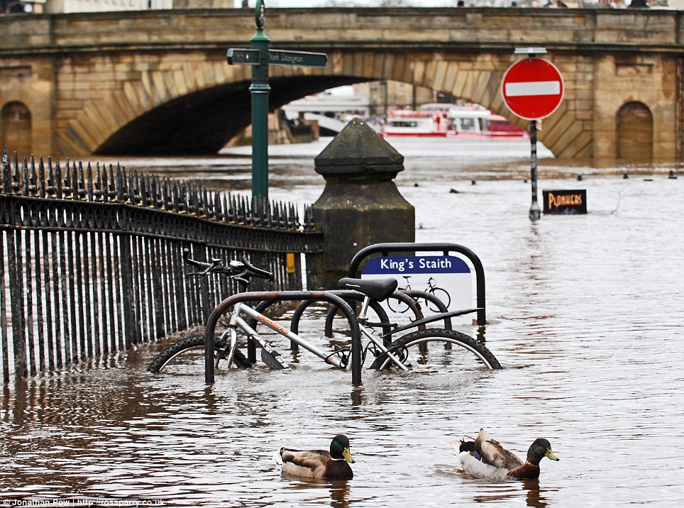
Live web cam at Kings Staithe. Click image to update
Defences are being deployed today/tomorrow at Clementhorpe,Tower Street and Peckitt Street. Rowntree Park will also remain closed tomorrow after closing tonight.
Advice and support:
When there’s flooding in York, the council will provide assistance, practical support and information as soon as it’s safe and appropriate to do so – all in a COVID secure way. Sandbags: If your home/property is at immediate risk of flooding – then you don’t need to contact us. We’ll provide sandbags to communities based on the latest forecasted levels. Rest Centres: We have teams on standby to help provide and support should you need this. Rest centres have been redesigned to ensure they are managed in a COVID-safe environment.
Social care support:
If you know of someone who may be in need of social care and support contact our Adult Social Care Team, email: adult.socialsupport@york.gov.uk or telephone: 01904 555111 (or textphone: 07534 437804, for sensory impaired callers), between 8.30am and 5pm, Monday to Friday.
Emotional support:
The Major Incident Response Team have trained volunteers on hand to provide emotional support to those affected by incidents such as flooding. The team are here to help and you can contact them on mirt@york.gov.uk
The Environment Agency river forecasters will continue to monitor the situation 24/7 and provide further updates. Please keep an eye out for the latest information and alerts from the Environment Agency for updates on river levels in the city.
Drivers, pedestrians and cyclists should not enter or travel through flood water which has risks from hidden obstacles and health hazards.
There has been heavy rain in the Dales overnight. This could mean that local rivers will break their banks.
It could be 2 or 3 days before the bulk of the water reaches and passes York.
There are currently no flood alerts in operation in the City although there is a warning in place for the Skip Bridge area (River Nidd) on the A59 which might affect those heading for the A1 or Harrogate.
Residents and businesses in York are invited to drop-in sessions in their local neighbourhoods to discuss recent flooding events.
As the city continues the clean-up operation following the rise in river levels caused by Storm Ciara and Storm Dennis, local residents and businesses are encouraged to share their feedback and experiences of recent events to help the council build upon the city’s resilience and improve local preparedness for the future.
Representatives from Emergency Planning, the Flood Risk Management Team, Community Involvement Officers and Councillors will be among those representing the council at the events across the city.
The upcoming drop-in sessions will be held in the following venues:
Fishergate: 11 March | Christian Science Church, YO10 4DE | 6-8pm
Tower Gardens and King’s Staith: 16 March | Quaker Meeting House, YO1 9RL | 5-7pm
Naburn: 17 March | Naburn Village Hall, YO19 4RS | 5-7pm
Fulford: 18 March | Fulford School (Main Hall), YO10 4FY | 5-7 pm (Presentation by the Environment Agency about Fordlands Road area at 6pm)
Skeldergate and Clementhorpe: 23 March | Southlands Methodist Church, YO23 1NX| 5-7pm
Acaster Malbis: 24 March | Acaster Malbis Village Hall, YO23 2TR | 5 -7pm
Cllr Keith Aspden, Leader of City of York Council said;
“I look forward to meeting residents and business owners across the city so we can listen and learn from the recent flood events. “This is a great opportunity to share with us what you thought worked, how we can improve protecting the city, or the best way we can keep you up to date with the latest information. “We recognise different areas have very different experiences and concerns, so we are holding drop-ins at key locations across the city so local residents can share their local and specific concerns. “Thank you to all the residents and businesses who have already shared their positive encouragement and useful feedback with us.”
Across the three week period of high river levels the council had:
crews focusing on community areas to start the clean-up operation – crews have washed down areas using sanitising disinfectant where appropriate
dealt with over 60 dangerous or storm damaged trees since Storm Ciara
deployed over 6,000 sandbags and 200 one-tonne sandbags across the city to help protect the most vulnerable properties.
installed around 25 pumps to clear water across the city
recycled any plastic sandbags. Contaminated sandbags will be disposed of through our contaminated waste removal. Sand will be reused at the council depot
cleared over 300 gullies, swept roads and cleared drains.
tankers were on standby for any surface water flooding incidents that occurred
regularly updated the www.york.gov.uk/flood page to share the latest updates and advice
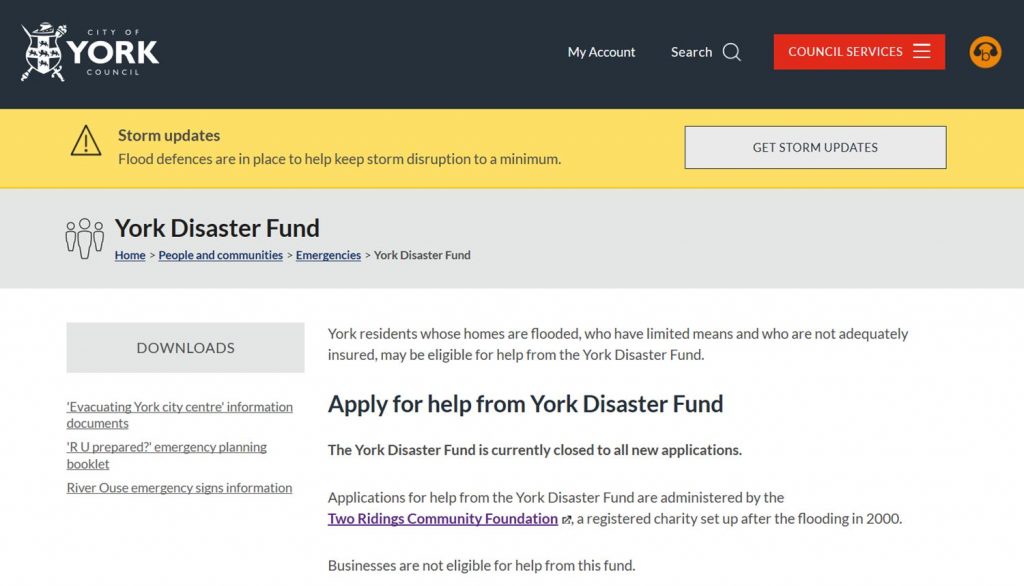
No new applications are being considered for the York Disaster Fund. The Fund was set up after the 2000 floods and is understood to have several hundred thousand pounds available to help those whose homes have been flooded.
It was last used after the 2015 floodsalthough it was then criticised for a lack of urgency in deploying the resources available. Homeowners needed help in the hours and days immediately following the flood but it was to be several weeks before any payments were made.
Thankfully this year relatively few homes have been flooded. Enquiries are referred to the Two Ridings charity web site. https://www.tworidingscf.org.uk/news/Their website is short on information while the Councils web site lacks advice for on the financial support available for flooded businesses.
Meanwhile one Councillor has had the foresight to remind Yorkshire Water that they will need to re-bait their sewers and drains to prevent rat infestations. The old bait is likely to have been washed away in the floods with some rodents being forced into gardens and homes.
The River Ouse peaked at 4.4 metres overnight and levels are now falling. The flood defences held. They are likely to remain in place for a few days.
It may be the end of the week before all riverside paths are reopened and cleared of debris.
The City owes a debt of gratitude to the Council staff, Environment Agency personnel and other organisation who successfully minimised the effect that the poor weather has had on the City over the last 2 weeks.