Bad week for congestion in York

There has been a lot of congestion in York over the last week or so.  With many visitors coming for the Christmas markets and the “Winter Wonderland” the influx is potentially good news for the local economy.

But transport systems have capacity limits and these were reached at times with the Designer Centre car parks effectively full and Park and Ride services compromised.

Queues at the hospital car park have caused delays on bus services while even cyclists have found it difficult to find vacant City centre cycle racks.

Lenin addresses people waiting in a Waitrose queue?

Add in the arrival of General Election campaigners eager to be filmed with a backdrop of crowds of people and the new security barriers, which hinder movement in areas like St Helen’s Square, and things have turned decidedly awkward even for pedestrians.

So, what’s to be done?

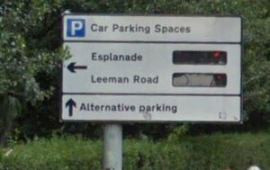
We have criticised the Council before about its failure to utilise modern technology to ease travel woes. The real time parking space availability map was removed from their web site last year.

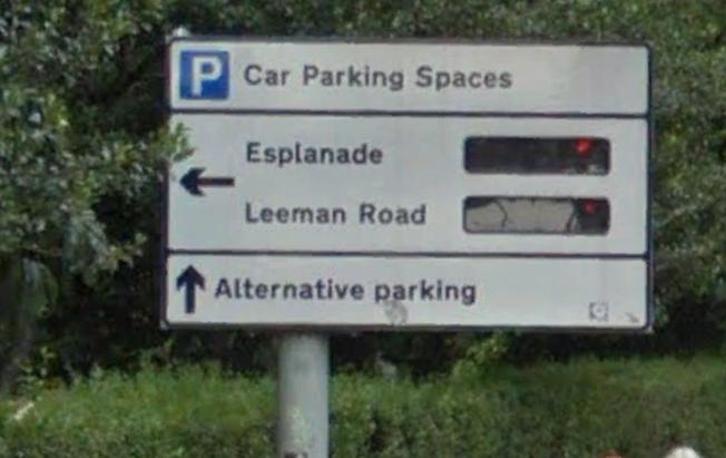
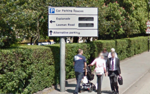
Many of the parking space availability signs which can be seen on arterial roads didn’t work for a long time.

On line site parking space availability web site abandoned by York Council

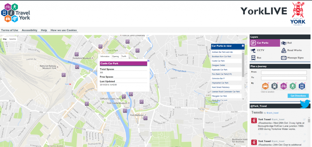
 A promised link through GPS to car navigation systems – which would help to direct vehicles to car parks where there were spaces – has not materialised.

As a result, vehicles still circle the City looking for spaces, which sometimes don’t exist, adding to congestion and pollution levels.

The York Council needs to raise its game.

On busy days, it should be tweeting updates on at least an hourly basis. Variable message signs on approach roads should be similarly updated. Local Radio has a part to play.

It would be relatively easy to add a CCTV link displaying the conditions at key locations to the Council web site. North Yorkshire already do this (albeit mainly to provide information on road conditions)

Modern problems need modern solutions.

Sadly at the moment there seems to be little sign of urgency at West Offices on the need to further improve traffic management in the City.

With the rain, come the weeds

Wetter weather will accelerate plant growth in the City. That means bigger weeds.

Usually by now the York Council has revealed its weed killing programme. Seems we have to go on waiting this year.

Name signs are already obscured
Sign posts need cleaning
Hazardous broken chain link fencing on Chapelfields snicket still not repaired
Verges still not cut

Traffic Speed on Wetherby Road

Speed sign on Wetheby Road which needs replacing

A meeting next week will consider a Council officials response to residents’ concerns about speeding traffic on Wetherby Road. The report follows the collection of a petition which asked for

  • the reinstatement and modernisation of both flashing speed warning signs on the road
  • the police to site their speed camera van in the built-up area on Wetherby Road on an occasional basis.

One of the flashing signs (on the odd numbered, Acomb Ward, side of the road) has been missing for over 2 years. It was faulty and the expectations were that it would be repaired and returned to its site.

Now officials say that speeds are lower on Wetherby Road and that, if a sign is too be provided, then it will have to be funded through the delegated budget held by Acomb Ward Councillors.  They go on to say that they approached the Councillors for the Acomb Ward (Cllrs Keith Myers and Stuart Barnes) in 2017 asking them to fund a replacement, but received no response. A new ward budget will be available from 1st April 2019 so the request could be renewed.

The report claims that vehicle speeds on the built-up section of Wetherby Road have reduced since the buffer 40 mph limit was introduced on the “rural” section 2 years ago.

Before and after speeds were recorded and are reproduced in a table (below).

Speed check results

As might be expected they show a small reduction in the speed of vehicles in the urban area (Eastbound), although speeds on the rural stretch actually increased.

The “after” figures were, however, taken in August 2017 before work on enlarging the ring road roundabout had been completed. One of the main reasons why residents collected the petition was a concern that the easier access across and from the A1237 would lead to increased speeds.

We think that the Acomb Ward Councillors should agree to fund a replacement speed sign.

new style speed signs

Elsewhere, at the same meeting, officials are recommending that the newer type of speed sign, which shows the actual speed of an approaching vehicle, should be trialled in the City. Unfortunately the sites identified, for the trial introduction of the signs, are all in eastern York. This type of sign is in common use elsewhere in Yorkshire and beyond.

The Council should agree to add Wetherby Road to the trial locations.

In additional they should support residents calls for the occasional “deterrent” siting of the camera van on the urban section of Wetherby Road

Car park occupancy in York

Car parking space availability signs still not working

It looks like the Council may finally be reinstating the remote car park space availability systems.

The real time information – available on street signs and via the internet – was abandoned some 5 years ago.

Now a £98,000 contract has been awarded to Swarco Traffic Ltd for the provision of new control equipment

Car parking availability signs still out of order

“On line” web guide scrapped

Car parking space availability signs still not working

The Council has about 20 signs on arterial roads which, until about 5 years ago, showed how many empty parking spaces there were at each car park.

Such facilities became commonplace on City streets more than a decade ago. They’re still to be found at many tourist destinations.

The FOI response has also revealed that the counters which allow the number of spaces to be identified, will only be reactivate on three of the signs before the end of the financial year.

The Council – after promising that its on line service, which also gives a guide to finding space, would be updated – has now been decommissioned.  The number of spaces shown has been incorrect for several years.

Users are now referred to the iTravel web site which contains only a list of car parks (and without an indication of the number of spaces at each).

Commercial sites like https://en.parkopedia.co.uk/ are much better.

There were also hopes that space availability would be linked to GPS systems to allow “Sat Nav” users to optimise their routes. Now it seems that driving round the inner ring road will continue to be the only way of finding a space.

That’s bad news for a Council leadership that claims to be trying to reduce pollution levels in the City centre, by cutting out unnecessary travel. Its also bad news fro some City centre traders who sell goods that require a purchaser to have access to their own transport.

York Council says parking signs will be fixed by end of March

At long last the Council has responded to our questions about the failure of its parking space availability policies.

Following our article published in December, which revealed that the Council’s web site was out of date and that many street signs were faulty, we asked the Council when repair work would be completed.

On line site parking space availability click to access

The on line map was a particular concern as it had not shown parking space availability for over 4 years and some of the listed car parks had actually closed.

After some delay, the Council has now said that the on line map – in line with a new mobile app – “will be updated by the end of March”.

This will include an update to the listed tariffs.

The delays in restoring the parking space availability feature (known as the Car Park Guidance System) is put down to issues with the slow roll out of the Council’s new fibre optic network. Apparently the car parking counting devices are currently being refurbished in time for the March relaunch.

The Council also confirms that all of the Variable Message Signs which can  be seen on the streets of the city were faulty.

The Council says it has

Parking space availability

“taken the novel step of working with a suppler to develop a new ‘technology package’ that can be inserted into the existing sign cases as this is a much cheaper way of renewing the VMS than simply replacing them.

The first four pre-production signs that have been used to test this approach are now operational and under test in the City, and the Heworth Green and Foss Islands Road CPGS signs are part of this group.

Work is now underway to apply this renewal technique to the five remaining City-centre ‘free text’ VMS and these will be back on street and operational by the end of March.

The remaining twenty CPGS ‘Insert’ signs (right) located in the City centre will be refurbished and brought back into use between April and August 2017″.

There are no plans to provide additional VMS signs in the City.

Finally the Council has confirmed that it is working with a number of GPS/SatNav suppliers to include real time parking space availability features on their devices. 

Consultation underway to revamp York’s signposting

Signpost in YorkAn award-winning consultancy which has worked on a number of nationally acclaimed projects for Derby, Oxford and Cambridge has been appointed to undertake a six-week consultation on behalf of City of York Council, into the future-look of York’s signposts, and in particular how this can benefit people with disabilities or dementia.