
The final report in the flooding which took place in the City on 13th August 2018 has been published.
click to read
More than 40mm of rain fell on large areas of the City in just over 15 minutes on the 13th August 2018, the intense nature of the storm led to significant areas of the cities road network being impacted by standing water and drainage systems were unable to cope.
Several properties were internally flooded and outbuildings and gardens of a greater number of properties were similarly affected.
Surface water flooding occurs when rainfall exceeds the capacity of open or piped systems or cannot soak into the ground. It typically occurs because of high intensity rainfall and can be aggravated by pipe or ditch blockage.
A map showing areas potentially vulnerable to surface water funding can be found here https://flood-warning-information.service.gov.uk/long-term-flood-risk/map
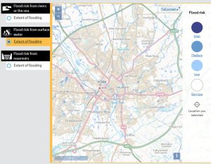
Click to view surface water vulnerability map of York
The York Council report is well written and makes several suggestions for improvements It refers to ongoing problems in Haxby but more generally highlights the gully reconstruction and cleaning programme that has been taking place over recent months.
The August event, when 120mm/hr of rainfall were recorded, is exceptional. Any event like this will cause some surface water accumulation but the City is now better prepared to deal with heavy rainfall in future.
One of the recommendations in the report is that network of digital rain meters is installed across the city.