Planning appeal decision goes against Spark container village

A Planning Inspector has rejected an appeal regarding the Spark container village on Piccadilly.

The owners of the units were hoping to avoid installing wooden cladding on the outside of the shipping containers as was required by the original planning consent granted in May 2017.

In August 2018 the Councils planning committee refused to remove the requirement for the containers to be clad in timber panelling. They concluded that the industrial style containers had an adverse impact on the appearance of the Central Conservation Area.

Spark appealed against this decision.

The appellants claimed that “that the financial implications of the approved installation would be prohibitive and would put the entire project at risk”.

However, the Inspector said that the costs of the cladding would have been known from the start.

The Inspector concluded “I find that no public benefits have been demonstrated that would outweigh the harm and there is no clear and convincing justification for the variation of the condition”.

Despite much prevarication, the controversial Spark project now seems to have reached the end of the road. Their lease expires next July anyway, and the Council will be eager to market the site for a more sustainable use.

The site is likely to be worth over a million pounds – money that the Council desperately needs to sustain the rest of its capital investment programme. The most viable use would be for a visitor attraction on the ground floor with either flats, offices or a hotel above.

The Council will also be expected to reveal how much their share of the “profits” on the development have actually been received.

The profit share arrangement was a key consideration when the Councils Executive agreed to release the site at their meeting in November 2016. The taxpayers investment of over £40,000 in infrastructure was to have been repaid from these “profits”.

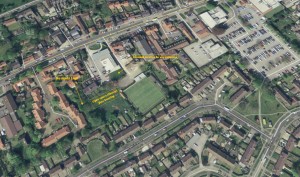
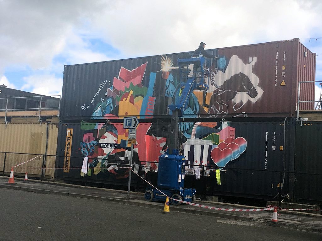
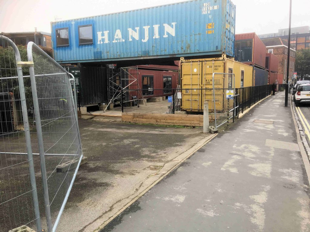
The shipping containers arrived on site in September 2017. They were widely regarded as “ugly” with street art graffiti on the Piccadilly frontage making the appearance even worse. The containers blight the Piccadilly area which is otherwise seeing signs of regeneration. Three new developments are currently underway on the opposite side of the road and a “Castle Gateway” masterplan is in the process of being approved.

The shipping containers arrived in September 2017

We think that Spark have been playing the Council along for many months.

The issue will be a major test of the effectiveness of the newly elected York Council. They must seek to quickly enforce the planning conditions on the site, while also recovering any outstanding debts.

They would also be wise to start marketing the site for future development.

Another planning forum for Westfield – we think not

The York Council has started consultation on whether to recognise an “Acomb and Westfield Neighbourhood Forum”

A small group of residents, mainly living in the Front Street area, want to establish a “neighbourhood plan”. It would supplement the Councils own Local Plan which will be subject to a public hearing over the summer months.

Proposed neighbourhood plan area (Acomb and Westfield)

Unfortunately, the area they hope to cover includes the whole of the Acomb and Westfield wards (approximately 10,000 homes). It would stretch from Foxwood to Boroughbridge Road, encompassing a disparate group of neighbourhoods with little obvious community of interest.

If agreed, it would be by far the largest such plan in the York area. In the main those plans that have been approved cover smaller villages. All have a shared commonality of interests.

Westfield is not short of groups which seek to influence Council policy.

There are several Residents Associations, a “planning panel” (which scrutinises planning applications), a “ward team” and a “ward committee” together with several “action groups” which tend to focus on stimulating, or preventing, specific developments.

Adding an additional tier of representation, although only a consultative body, would involve additional costs and could lead to confusion about roles and responsibilities.

When it comes down to it, Foxwood has little in common with Chapelfields or the Gladstone Street area.

It has even less shared interest with Ouse Acres and vice versa. Arguably Foxwood has more in common with the Woodthorpe area.

In our view, this proposal represents an unwelcome diversion and could take resources away from the key task of raising public service standards in the area. Residents Associations are bested suited – and of the right scale – to identify changes that need to be made in local neighbourhoods.

They deserve more Council support.

In most built up sub-urban areas, there is little scope for redevelopment anyway with the focus being to retain existing open spaces. There is an opportunity for more public open space on land lying between the existing development and the A1237 bypass. The proposed Neighbourhood Plan boundaries exclude this land from consideration.

Ward Councillors are already aware of the need to move the extra public open space issue forward.

Front Street in older times. This part of Westfield may require better protection from developers in the light of the current problems at the Bowling Club building site.

There may be a case for a neighbourhood plan covering the Acomb village conservation area and its immediate environs.

The “forum” organisers would be wise to focus on a smaller area like this – where there may be a need for more clarity on its future – rather than try to “boil the, proverbial, ocean”.

In the meantime residents should email the Council to oppose this unnecessary proposal.

neighbourhoodplanning@york.gov.uk

Call for compensation after Council confirms that it did not consult on building compound location

In response to a Freedom of Information request the York Council has now confirmed that it did not consult neighbours or local Councillors before issuing a license which allowed a building contractor to occupy the “old allotments” site at the rear of the library car park.

This site has been owned by the Council for over 15 years. The developers of the adjacent bowling Club land (which does have planning permission) had previously said that they did not want to combine the two sites to provide a abetter overall layout.

Work on the site disturbed residents living in South View Terrace and part of Lowfields Drive.

The first that residents knew of the arrangement, was when heavy plant moved onto the site and started to clear it. This prompted complaints about noise, dust and vibrations.

Spoil heap heights reached over 4 metres at one point.

Local fauna and flora on the site were badly affected.

The Council now says that it granted a license to occupy its land on 8th April. There was no consultation undertaken with neighbours.

Residents complained to the Council on 16th May about the problems being caused.

It wasn’t until 28th May that the Council wrote to affected neighbours telling them about the license.

The Council says that working hours on the compound are restricted to 8:00am – 6:00pm, Mon – Fri plus 9:00am – 1:00pm on Saturdays.

The Council says that “The compound licence requires the developer to leave the property in a clean and tidy condition at the end of the licence, including the removal of hardcore”.  

It goes on to say that it expects the compound to be in use for 12 months.

An investigation into whether the developers have the necessary planning permission to use the building compound is still underway.

In our view affected residents have suffered unexpected and unreasonable disruption and should be entitled to compensation.

It is possible that the matter may be referred to the Local Government Ombudsman

York’s green spaces; going, going…

It is sad to see so many green spaces in the City being gradually eroded.

The reality of planning decisions, taken by the Council over the last few years, are rapidly becoming clearer. The trend is particularly evident in west York where former school playing field have proved to be vulnerable.

It started with the development of the playing field at the former Our Lady’s school site on Windsor Garth. The “Hob Stone” estate took up the whole of the site with no open space retained.

Next was the controversial decision to build on the Lowfields playing field. The decision was made worse when over £400,000, intended to fund alternative sports pitches, was earmarked for a site near Bishopthorpe, which is some 3 miles from Lowfields.

Concrete now dominates the Lowfields school playing field

The Hob Moor playing field has been torn up and is now part of a building site
The Acomb Bowling club and adjacent Council owned land on Front Street is now also a building site

There are alternative brownfield (previously developed) sites in the City. Strangely the local MP over the weekend announced her opposition to building 2500 homes on the land to the rear of the station while planners have omitted the Strensall army camp from Local Development Plans.

There seems to be little reason why a development at the latter could not be restricted to the “built footprint” of the former army buildings. This would still leave large amounts of new public open space. That option is under consideration as part of the latest consultation on the Local Plan

But for west York the outlook remains bleak. The Council is still dilly dallying on proposals to replace the Multi User Games Area on Kingsway West. The existing one is no longer usable as it is no part of a buildng compound.

…and the newly elected Council, despite lofty talk of having a new “stray” in the City, has noticeably failed to put any flesh on the bones of the idea. Prompt action is needed to secure more public open space on the periphery of the City.

Currently there is little sign of any urgency, or even engagement, by the occupants of West Offices.

Report casts light on life in Acomb since Roman times

An archaeology report, produced as part of the investigations into the bowling club development project on Front Street, has provided a further insight into the history of the village.

The report says that, “in February 2005 On-Site Archaeology carried out an archaeological evaluation on the disused allotments located immediately to the west of the current site. Within one of the evaluation trenches two small pits containing late 1st to mid 3rd century Roman pottery were recorded, cutting into the natural sand. A residual sherd of late 1st to early 2nd century pottery was recovered from a subsoil deposit in one of the other trenches”

The allotments land has now been bulldozed to form a building compound. No mitigation measures have been taken to preserve or record any archaeological remains on that site (which is owned by the York Council).

The report goes on to say, “There is no evidence of occupation during the Anglo-Saxon period although the name ‘Acomb’ is Anglo-Saxon in origin meaning “at the oaks”.

“The mediaeval period is when the village of Acomb took on a known form with the focus of the village being the area between The Green and Front Street. Acomb is listed in the Domesday survey of 1086 as a manor with 14 rent-payers. The Church of St. Stephen is an 1830 construction replacing an earlier 12th century church with possible pre-Conquest origins. Archaeological work has taken place behind 12-26 The Green, which produced evidence for mediaeval domestic activity and possible ploughsoil relating to medieval crofts or garden plots An evaluation carried out by OSA in March 2007 to the rear of 95 Front Street revealed late medieval boundary ditches containing pottery dated to the 15th and 16th centuries”.

The findings of the investigation can be read by clicking here .

A report on contamination on the site can be read by clicking here

Anger mounts as York Council ignores complaints about spoil heap on Front Street

As reported earlier in the week, residents living next to the Library in Acomb were dismayed to find that demolition contractors had taken over the adjacent Council owned land. The trespass apparently formed part of the plan to build on the bowling club

Plan shows Council owned site which has been bulldozed

Several days later and things are even worse.

A 4 metre high mound of spoil has now appeared. It is only feet from the gardens of nearby homes

Spoil heap is nearly 4 metres high

The Council appears to have done nothing other than send an environmental protection officer to the site to make an inspection.

The Council has remained tight lipped about whether they have granted permission for the work and whether the actions of the contractor breach planning regulations.

There are also questions about whether the activities conflict with the Wildlife and Countryside Act 1981

There are complaints about early morning activities. Construction work on the bowling club site is conditioned not start until after 8:00am,.

It is very disappointing that the Council has not acted more promptly to reassure residents about what is going on.

Not a good start for the authorities new Executive members of whom we had expected better.

Lowfields misery continues

The Lowfield Action Group Facebook page makes it clear that residents have major concerns about the current development works in the area.

There are continuing complaints about noise, dust and working hours extending beyond those approved in the planning permission.

Communications from the Council have been minimal although another exhibition is promised prior to the main contractor starting on site. The current contractor is only undertaking clearance and layout works.

One piece of good news is that work on providing an additional 3 parking spaces on Tudor Road is due to start next week.

The Council latest planning application, which should have been determined by the end of April, it is still outstanding.

There is still no sign of a planning application for the Care Home much less the health centre and “police station”, not that they were ever likely to materialise anyway.

“Yorspace” are apparently still trying to raise funds for their “communal living” scheme while the Councils decision to sell them land at a discounted rate may yet prove to have been illegal.

Hopefully the new Council will be able to find someone competent and sensitive to local residents views when they decide who will lead on housing and planning matters for the next 4 years.

Certainly communication and supervisory systems need major improvements.

Share your views on the York Station planning application

Plans that will see the front of York Railway Station transformed with the removal of Queen Street Bridge and reorganising the layout leading into the station are now available to comment on using the planning portal.

The plans were submitted last month following an extensive public consultation in summer 2018 which saw over 1,500 people share their feedback on the scheme. People now have the opportunity to comment on the submission at www.york.gov.uk/planning (ref no19/00535/FULM and 19/00542/LBC). Following this it is expected to go before the planning committee in summer.

Following feedback from the public consultation designers altered the master plan to take into account the comments.

Different landowners and funding arrangements mean that plans for the area will be delivered in phases, each with appropriate partners, planning approval and timescales. We’re working closely with Network Rail, London North Eastern Railway and Northern Powerhouse.

The project to transform the front of York Station will receive funding through the West Yorkshire-plus Transport Fund, and the Leeds City Region Growth Deal – a £1 billion package of Government investment through the West Yorkshire Combined Authority (WYCA) and Leeds City Region Enterprise Partnership (LEP) to accelerate growth and create jobs across Leeds City Region.

For more information about York Station front visit www.york.gov.uk/stationfront

Huge York central development gets planning approval

A major development behind York railway station got the go ahead from the Planning Committee last night.

York Central site

It will provide hundreds of new homes and jobs over the next decade or so.

The site has been derelict, and mostly unused, for over 20 years. The progress made in bringing forward the site will probably be recorded by history as the major achievement of the current Council coalition administration.

The development is not without controversy.

The transport plans in particular lack the quality and imagination that many had hoped for. The developers will need to refine access arrangements from the City centre to Leeman Road particularly for pedestrians and cyclists.

Bus services must include a frequent park and ride link to off site parking spaces at Poppleton Bar.

Some courage will be needed if the site is to be declared an “ultra low emission zone”. Such a step would be an acknowledgement that the declaration of a “climate crisis” by the Council a few days ago was more than just rhetoric.

But overall the decision is a good one for the City, not least because it will reduce the pressure to build on green fields.

Hopefully we will see some development on site before the end of the year.