Flooding in York – Update report publised

A further report on plans to deal with flooding in York will be discussed at a Council meeting next week.

Funding has been allocated to the Environment Agency (EA) following the floods in 2015 to renew existing and provide new flood defences across the city, £17m has been allocated to the Foss Barrier improvements and £45m to the wider flood defences across the City.

Following the development and publication of the York Five Year Plan (https://www.gov.uk/government/publications/york-5-year-flood-plan) the EA have developed the Defra Strategic Outline Business Case and financial approvals have been sought and obtained from Defra.

The report does not provide an update on issues connected with Hob Moor back

click to read

Good work by York Council as Hob Moor access restored

Anyone for a shower?

There are still too many blocked drainage gullies in parts of York. This mornings rain demonstrated the scale of the problem with flooding at the bottom of Hamilton Drive East a particular hazard. There were similar if less spectacular problems on Nigel Grove and Foxwood Lane. All have been reported for attention

53% of road drains found to be blocked in York Council survey

£5 million cost to upgrade whole system

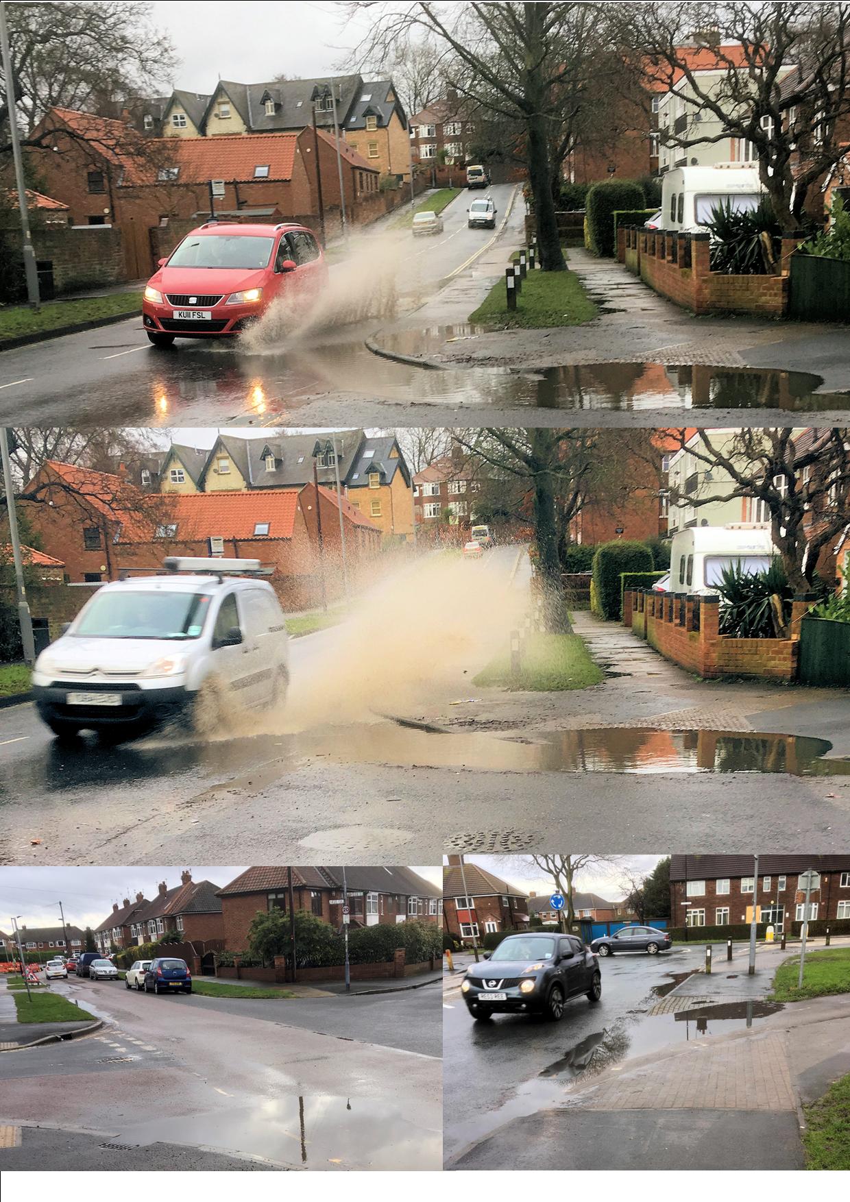
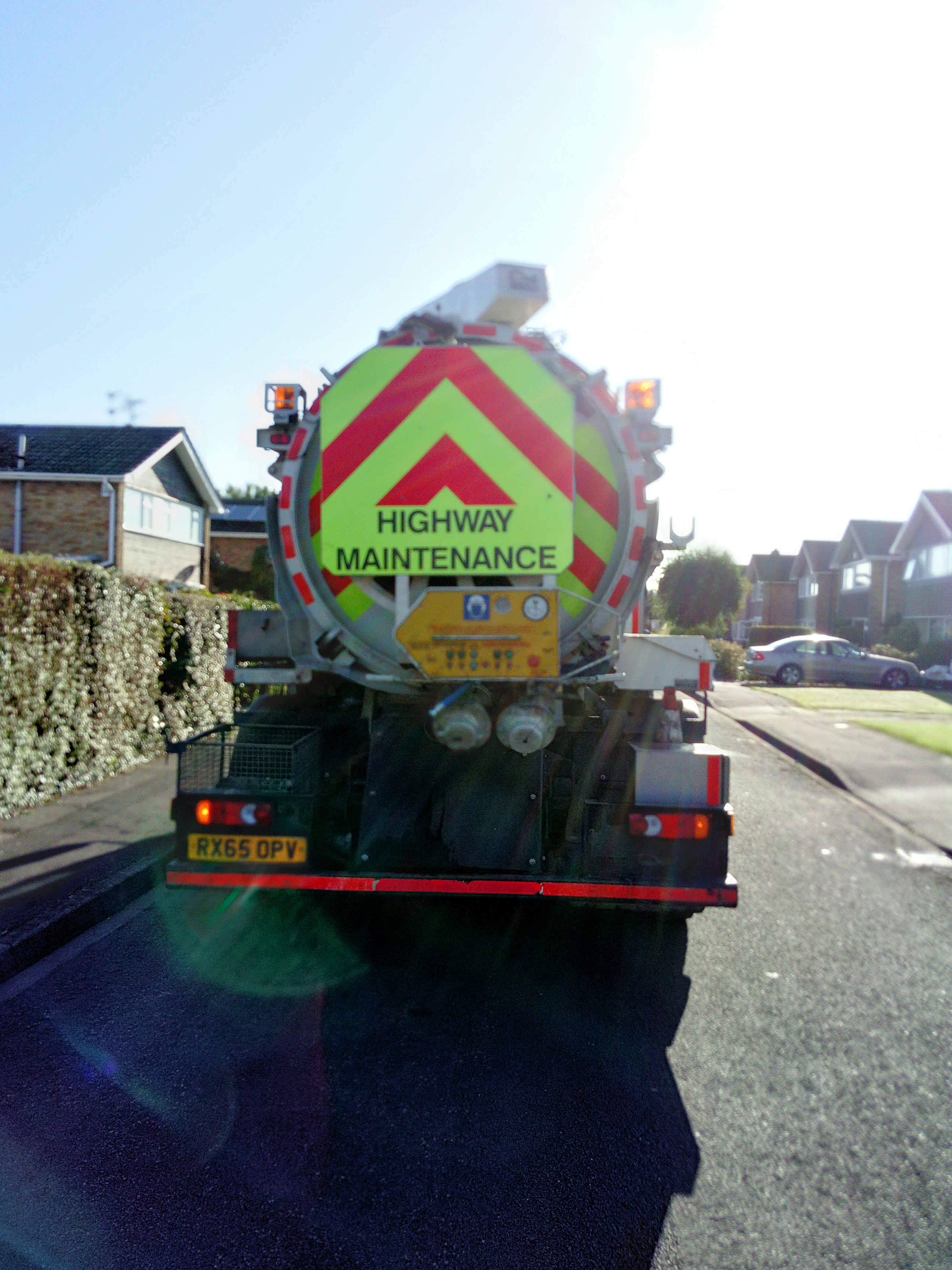
Considerable concern was expressed in 2015 when it was discovered that large areas of highway were flooding during wet weather. Many residents complained that the reduced  gulley cleaning service – introduced by the last Labour led Council – was inadequate. The City has over 42,000 gulleys.

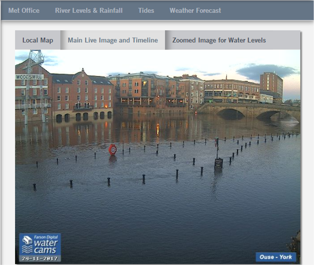
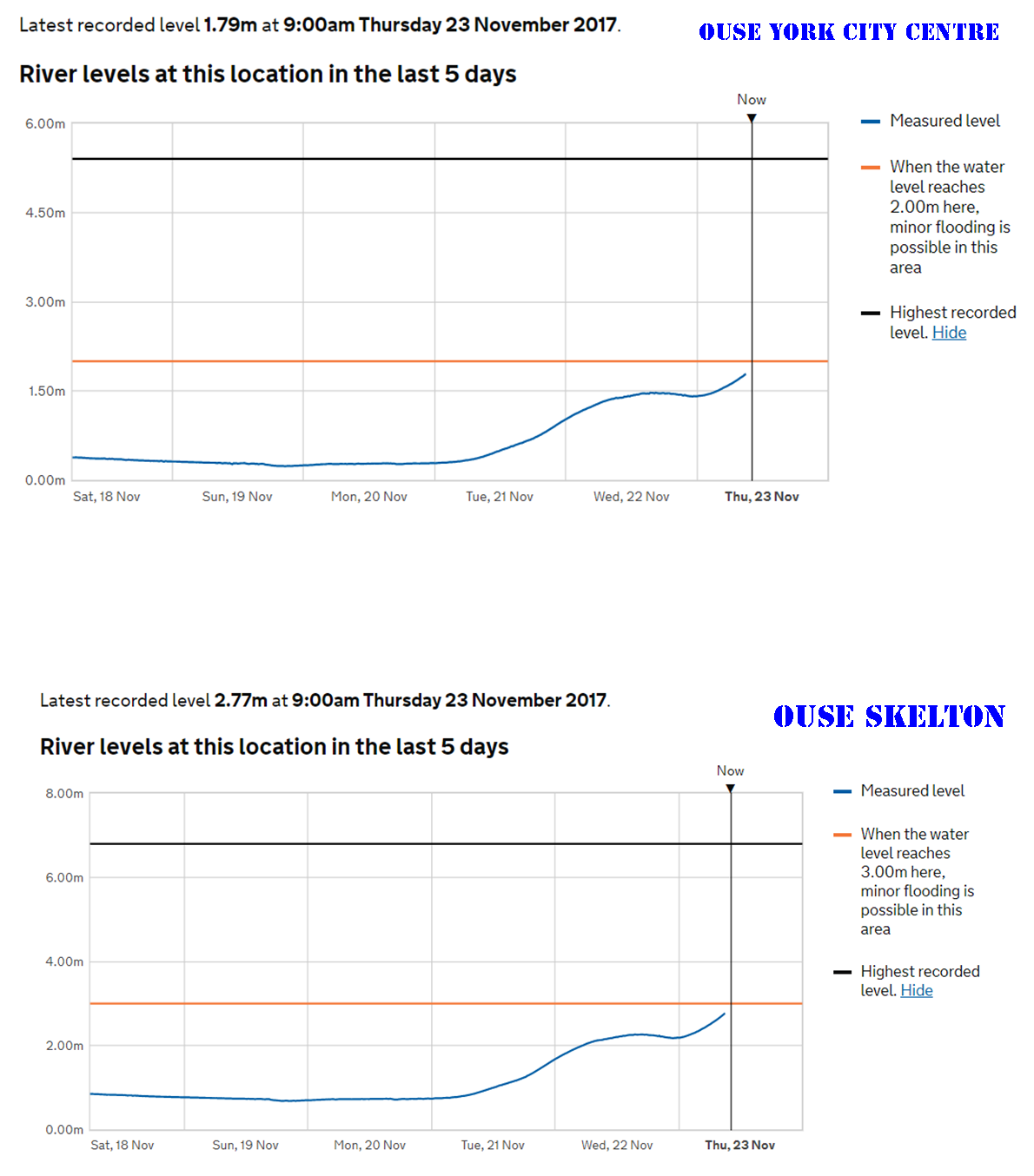
In 2016 and 2017 there were major surface water problems in several parts of York.

The led the new Councillor – Andrew Waller – responsible for surface water drainage systems to institute a review of standards.

The initial findings of the comprehensive survey into the effectiveness of drainage systems will now be presented to a meeting next week

The report says,

“To date more than 35,000 of the 43,690 known gullies have been logged, investigated and cleansed as part of the capital funded investigation process, a flood risk assessment process has been previously carried out to ensure key assets have been prioritised.

53% of all assets were found to be blocked but significant work has ensured the majority of the system investigated to date is operating effectively, however more than 900 assets will require wider engineering works to ensure they can operate effectively”.

With many gullies now cleared, the report goes on to say,

“Subsequent heavy rainfall events have given rise to reduced numbers of complaints and reports of localised flood incidences, this is a clear indication of the success of this process, however, significant rainfall such as experienced on the 23rd August this year can still overwhelm a well maintained and operable drainage system as their design capacity would be compromised”.

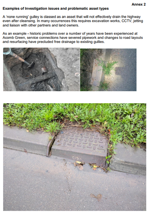
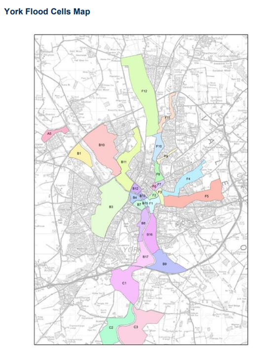
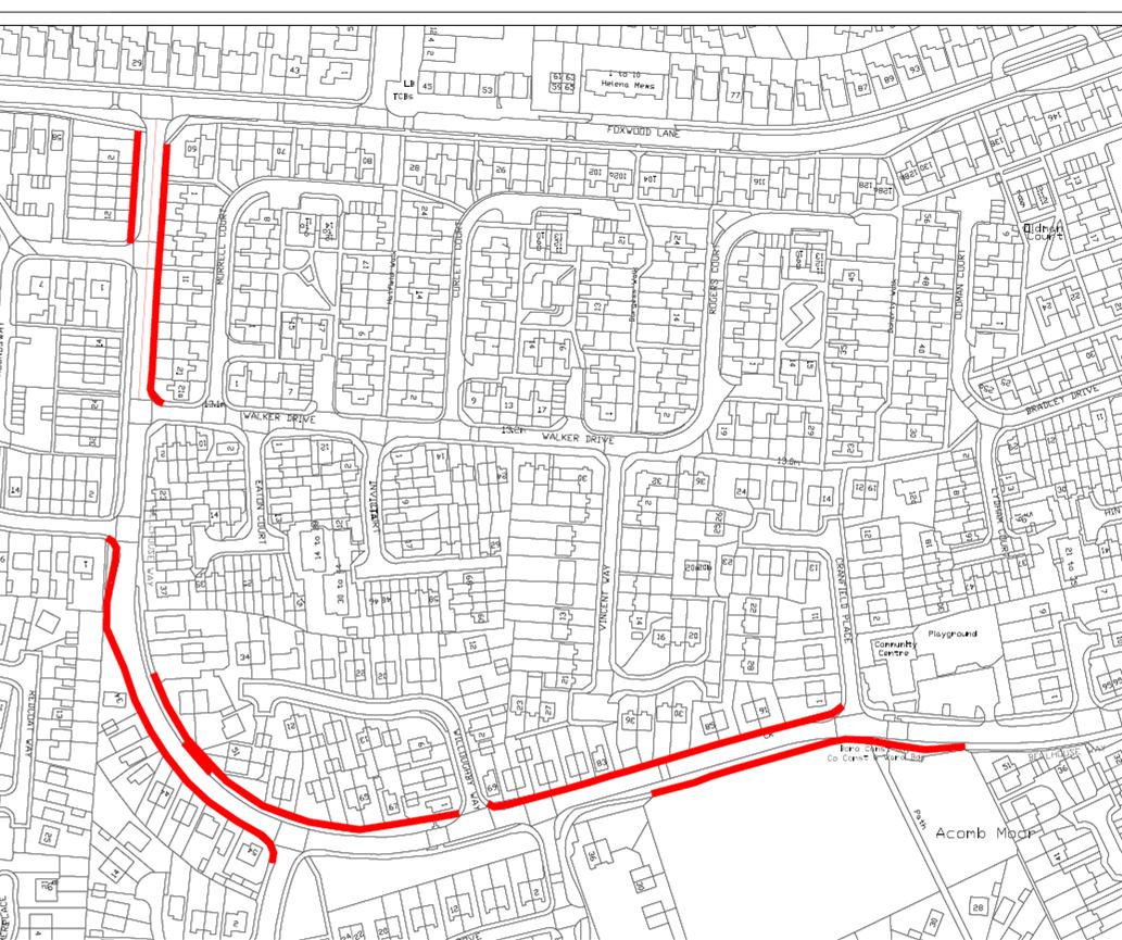
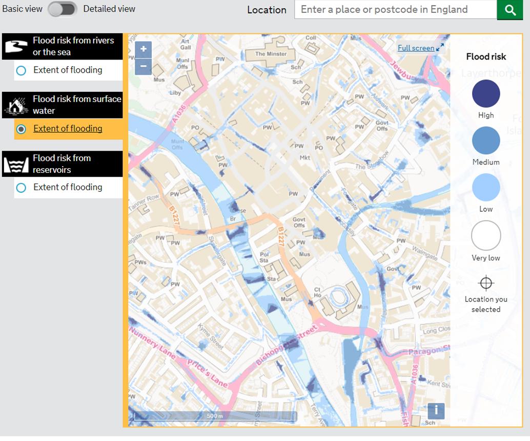
The findings of an investigation into surface water ponding on Acomb Green is included in the papers (see below)

York flood plan update – Works start in March

It looks like work could start in March on works aimed at reducing flood risk near Westfield (Hob Moor) beck.

The Environment Agency has today published an update report on its planned works.

The report is the latest response to flooding in late December 2015 followed an intense period of rainfall across November and December due to the impacts of Storms Desmond  and Eva. Record river levels were observed in many river catchments across the north of England. More than 4000 homes and 2000 businesses flooded across Yorkshire with 453 properties and 174 businesses flooded in York.

Funding has been allocated to the Environment Agency (EA) following the floods to renew existing and provide new flood defences across the city, £17m has been allocated to the Foss Barrier improvements and £45m to the wider flood defences across the city.

The report will be discussed by the Council at a meeting taking place on 4th December


York braced for flood season

It’s that time of year again and thoughts of some York residents will focus back onto flood risks.

The first flooding of the season has occurred in Craven overnight. That water will be heading in York’s direction.

In tte main the rivers to keep an eye on are the Swale, the Ure, the Nidd and the Foss. All contribute to Ouse river levels in and near York

You can check real time river levels at this site Click 

River gauges in and around York as of now (am 23rd November) are still below flooding levels but there are concerns about the Swale and Ure. The Swale at Myton is now in flood range  as is the Ure at Boroughbridge.

It would be unusual for major flooding to occur in the City as a result of recent rainfall. Usually flooding happens when a combination of factors (sodden ground, snow melt, sustained rain) come together.

Better safe than sorry though so we recommend the Flood Warning Alert service Click

Footpath resurfacing delayed but gullies being cleaned in Foxwood

The footpath resurfacing works on Bellhouse Way are currently running about one week behind schedule. Affected frontagers have been advised of the new timetable

Good progress was made yesterday by the gulley cleaner operating in the Foxwood area. Good to see the Council getting ready for winter after the recent problems experienced in parts of the City with surface water.

Flooding in York – where to find information

The government produces maps which show which streets in the City are subject to surface water flooding risks.

Of course, as we saw this morning, other areas can be vulnerable if the capacity of drains is exceeded (and/or they are blocked).

You can access the information here: https://flood-warning-information.service.gov.uk/long-term-flood-risk

Real time flooding maps can be found via this link https://flood-warning-information.service.gov.uk/map

Real time river level gauges can be found here http://www.gaugemap.co.uk/#!Map

The York Council’s surface water management plan can be downloaded from this link http://www.york.gov.uk/download/downloads/id/11055/surface_water_management_plan.pdf

York Council to receive update report on 5 year flood plan

Naburn Weir

A meeting taking place on 3rd July will receive an update report on the progress made in reducing flooding risks in York.

The meeting will also receive reports on addressing flooding problems in Fulford and on plans to make significant changes to Osbaldwick beck in the Hull Road park area.

The flooding in late December 2015 followed an intense period of rainfall across November and December due to the impacts of Storms Desmond and Eva.

Record river levels were observed in many river catchments across the north of England. More than 4000 homes and 2000 businesses flooded across Yorkshire with 453 properties and 174 businesses flooded in York.

Funding was allocated to the Environment Agency (EA) following the floods to renew existing and provide new flood defences across the city.

£17m has been allocated to the Foss Barrier improvements and £45m to the wider flood defences across the city.

The Environment Agency has provided a summary report for the meeting and also an analysis of options for changes to Naburn Weir

Naburn Weir