Pollution levels still low in York

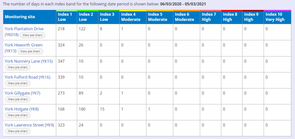
Air quality remains good, and pollution levels very low, on Gillygate and at other monitoring sites in the City.

Traffic levels are, however, higher than were recorded during lockdown 1 last spring. They are likely to increase further from Monday when there will be a general return to school.

It will be April before shops and offices reopen.

Council plans to reduce road capacity at the Gillygate/St Leonard’s Place/ Bootham junction seem ill timed and insufficiently thought through.

The plans could increase congestion by 30%. That would delay bus services including the vital park and ride links.

In the meantime, residents can monitor hour by hour pollution levels by clicking this link

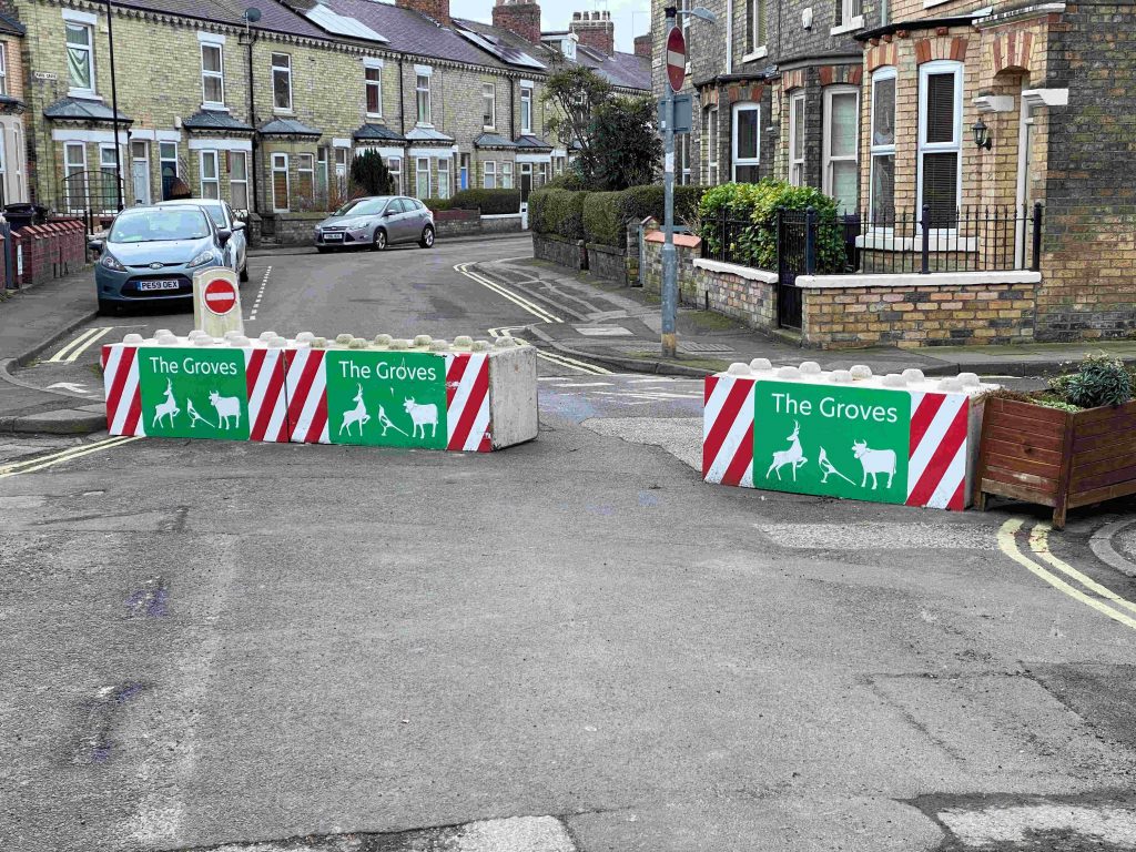
Meanwhile we understand that the Council will delay its assessment of the effects of road closures in The Groves area.

A review was due in the spring.

They are right to delay as traffic volumes and movements have been untypical during the Lockdown period.

However, it does mean that a reassessment of some of the more questionable aspects of the scheme – such as contraflow cycle routes – will remain in place as traffic volumes and safety hazards increase.

There have been no queues involving deer or cattle in The Groves during recent months

The trees are coming

The scale of the York Council’s afforestation plans are becoming clearer.

A meeting taking place next week will hear that increasing York’s tree cover from the current 10.76% of the total area to 13% (national average) by 2050 would require 608 ha of new cover, or 21 ha per year.

York currently has 2,926 ha of tree canopy cover, representing 10.8%
of its total area. 60% of this canopy cover is made up of trees outside
woodlands.

The report says, “the rate of viable delivery imposes a significant constraint on new canopy cover. The York Community Woodland project (Knapton Forest) in West York aims to deliver 50-60 ha of new tree cover over the next two years.

A 13% target for 2050 would require a similar level of growth every two years“.

City of York Council is a member of the White Rose Forest (WRF)
partnership which aims to provide tree canopy across large parts of Yorkshire.

The WRF project assumes an ambition for a 13% target for tree canopy cover by 2050, equating to around 22-27 ha per annum. This target would result in “an annual carbon sequestration rate at 2050 of circa 9,000tCO2 per year; equivalent to around 1% of the regions total CO2 emissions between 2020-2050“.

As with the Knapton Forest project, there has been no public consultation on the plan. The costs are unknown although, based on the Knapton land values, they could mean a taxpayers bill for several hundred million pounds.

The report doesn’t assess the scope for increasing tree canopy cover on existing amenity areas or private gardens.

The effect on food production is also unclear. The areas selected for afforestation are mainly grade 2 agricultural land.

They cover large areas near Poppleton, Skelton and Elvington.

click for detail

Limited progress on pothole repairs

Of six highway defects reported on Saturday, the Council has agreed to address only two of them.

Further work is promised on Gladstone Street and School Street.

Elsewhere it seems there is no prospect of repairs on Walker Drive, Vincent Way, Hotham Avenue or Lowfields Drive

The Council seems to be no closer to bitmacing the small section of verge on Kingsway West, near Newbury Avenue, which has been subject to overrun damage for over 5 years now

We understand that the Council is considering using the little Green Lane garage area as a compound during housing modernisation works. A storage unit has already appeared there

Work on new Foss barrier progressing

Work on the replacement Foss barrier is progressing again as river levels fall.

The huge new gate was lifted into place last month

The original barrier was installed in 1987 but was overwhelmed in the 2015 floods.

A new pumping house has been installed along with the barrier and improved banking.

The cost of the project is put at £37 million.

In a separate scheme, the nearby “Blue Bridge” cycle and pedestrian facility was also refurbished last year.

Tree felling near Knapton Forest

The York Council announced last week that it had obtained external funding for the planned new “forest” near Knapton.

Ironically the first signs of activity on the proposed site have been tree felling works over recent days. (Clearly some of the trees were diseased).

No sign yet of any environmental evaluation.

The expectation was that there would be an attempt made to justify turning good quality agricultural land into a forest, with benefits and adverse consequences clearly enumerated.

Seems that will not happen nor has any public consultation on layout and other options yet started.

Issues reported in west York

It looks like many highways defects have been left waiting for attention for so long that expensive remedial works are now needed.

Many carriageways which needed patching in the summer and autumn were ignored. Now some are worn down to the hardcore base while others have multiple surface defects. Several represent a hazard for two wheeled transport users.

We have reported the following streets (but these may just be the tip of the iceberg).

  • Walker Drive
  • Vincent Way
  • Gladstone Street
  • Hotham Avenue
  • Lowfields Drive
  • School Street

There are also some problems also with leaf and tree detritus. We’ve reported two areas

  • Green Lane
  • Kingsthorpe

Finally builders waste has been dumped in the little Green Lane garage area. We’ve asked for it to be removed.

Little Green Lane garage area 19th Feb 2021

Significant changes to Lowfields Plans

Planning applications (see below) have been submitted which would see changes made to the Lowfields development. Many are relatively minor although some may cause concern for neighbours

Working hours

Saturday working until 3:00pm will be allowed on parts of the site. A Council official has already agreed to these changes which will permit work to continue on internal works, external paving and brick laying.

Officials say that the proposal is in line with government relaxations in the wake of the pandemic and lockdown restrictions.

The concession lasts until 2nd June 2021.

Proposed boundary arrangements
York Council Email
Boundaries

The perimeter railings are now to be retained. This proposal will be welcomed by many. The railings are generally in good condition and offer enhanced security protection.

Likely to be less welcome is a plan to install a 1.8 meter high closed boarded fence immediately behind the railings. While this may improve privacy, such arrangements have not proved to be successful elsewhere (Hob Stone, Cornlands Road/Redder Rad snicket).

The are maintenance problems for both sets of fences. Progress for mammals like hedgehogs is obstructed by close boarded fences, while an opportunity for compensatory planting is missed.

Undergrowth inevitably builds up between the two layers which is difficult to control.

We will be writing to the planning authorities to say that the inner fence should be replaced with screen planting, which would be better for both wildlife and for the environment.

Boundary treatments
Other changes

A complete list of changes is reproduced below.

The ridge and eves heights on the houses are being reduced while photovoltaic cells are being installed to generate power.

There still has been no statement from the Council about the future of the site reserved for “public buildings” or of the Yorspace communal living plots.

After the snow may come the floods

Forecasters are saying that it will get warmer next week.

With the thaw will come rain and concerns about flooding.

The worse floods in York have usually occurred when the ground has been saturated, where there has also been rapid snow melt upstream and when this has coincided with heavy rain.

We hope this doesn’t happen next week.

Meanwhile we have had some rare winter views to enjoy in and around the City over the last few days.